San Felipe Pueblo geodata
San Felipe Pueblo (New Mexico) is a populated place; located in United States in America/Denver (GMT-6) time zone. With population of 2,404 people, there are 10838 cities with bigger population in this country. Compared to other cities in United States, 73% of cities are located further ↑North; 84.3% of cities are located further →East and 97.2% of cities have lower elevation than San Felipe Pueblo. Note1


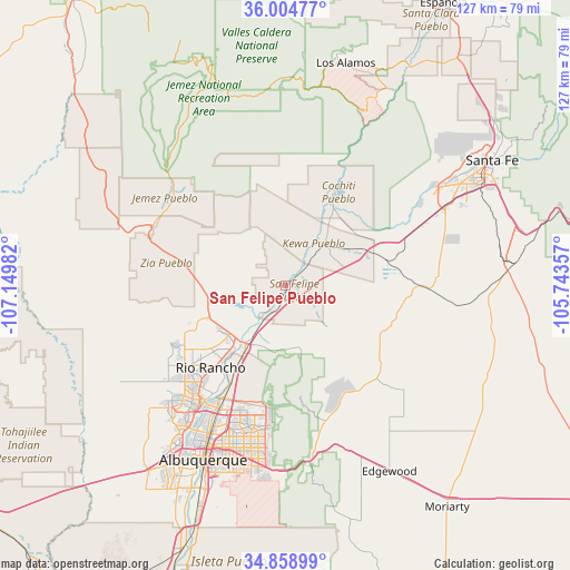
San Felipe Pueblo GPS coordinates[2]
35° 26' 2.112" North, 106° 26' 48.084" West
| Map corner | latitude | longitude |
|---|---|---|
| Upper-left | 36.00477°, | -107.14982° |
| Center: | 35.43392°, | -106.44669° |
| Lower-right: | 34.85899°, | -105.74357° |
| Map W x H: | 127.4×127.4 km | = 79.2×79.2mi |
| max Lat: | 71.29058° ⇑73% North |
| San Felipe Pueblo: | 35.43392° |
| min Lat: | ⇓27% South 19.06759° |
| min Long | San Felipe Pueb | max Long |
| -171.73463° | -106.44669° | -66.98998° |
| W 15.7%⇐ | ⇒84.3% E |
Elevation
Elevation of San Felipe Pueblo is 1561 m = 5121 ft, and this is 1266.2 m = 4154 ft above average elevation for this country.
| Max E: |
3189 m = 10463 ft | 2.8% |
| San Felipe Pueblo | 1561 m 5121 ft | |
| Avg. | 294.8 m = 967 ft | |
Min E: |
-60 m = -197 ft | 97.2% |
See also: United States elevation on elevation.city.
Geographical zone
San Felipe Pueblo is located in North temperate zone (between Tropic of Cancer and the Arctic Circle). Distance of this Northern Tropic circle is 1334 km =828.9 mi to South.| Distance of | km | miles | from San Felipe Pueblo |
|---|---|---|---|
| North Pole | 6067.2 | 3770 | to North |
| Arctic Circle | 3461.3 | 2150.8 | to North |
| Tropic Cancer | 1334 | 828.9 | to South |
| Equator | 3939.9 | 2448.1 | to South |


Nearby cities:
15 places around San Felipe Pueblo: (largest is in red/bold)
• Algodones
6.6 km =4.1 mi,  206°
206°
• Bernalillo
17.6 km =10.9 mi, 212°
• Cochiti
21.3 km =13.2 mi,  24°
24°
• Cochiti Lake
25.8 km =16 mi, 22°
• Corrales
26.2 km =16.3 mi, 213°
• Enchanted Hills
17.1 km =10.6 mi,  230°
230°
• La Cienega
32 km =19.9 mi,  63°
63°
• Peña Blanca
18.1 km =11.2 mi,  32°
32°
• Placitas
14.3 km =8.9 mi,  171°
171°
• Rio Rancho
29.8 km =18.5 mi,  221°
221°
• San Antonito
31.4 km =19.5 mi,  163°
163°
• Sandia Heights
28.9 km =18 mi,  188°
188°
• Santa Ana Pueblo
15.6 km =9.7 mi,  267°
267°
• Santo Domingo Pueblo
11.6 km =7.2 mi,  39°
39°
• Zia Pueblo
26.1 km =16.2 mi,  288°
288°
Sources, notices
• [Note1] Compared only with cities in United States existing in our database
• [Src1] Map data: © OpenStreetMap contributors (CC-BY-SA)
• [Src2] Other city data from geonames.org with taken over terms of usage.
• [Src3] Geographical zone / Annual Mean Temperature by Robert A. Rohde @ Wikipedia
