La Mesa geodata
La Mesa (New Mexico) is a populated place; located in United States in America/Denver (GMT-6) time zone. With population of 728 people, there are 18421 cities with bigger population in this country. Compared to other cities in United States, 88.3% of cities are located further ↑North; 84.5% of cities are located further →East and 94.4% of cities have lower elevation than La Mesa. Note1


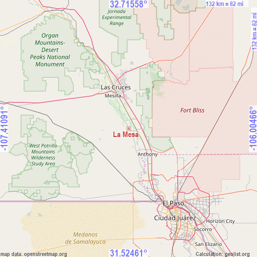
La Mesa GPS coordinates[2]
32° 7' 19.344" North, 106° 42' 28.008" West
| Map corner | latitude | longitude |
|---|---|---|
| Upper-left | 32.71558°, | -107.41091° |
| Center: | 32.12204°, | -106.70778° |
| Lower-right: | 31.52461°, | -106.00466° |
| Map W x H: | 132.4×132.4 km | = 82.3×82.3mi |
| max Lat: | 71.29058° ⇑88.3% North |
| La Mesa: | 32.12204° |
| min Lat: | ⇓11.7% South 19.06759° |
| min Long | La Mesa | max Long |
| -171.73463° | -106.70778° | -66.98998° |
| W 15.5%⇐ | ⇒84.5% E |
Elevation
Elevation of La Mesa is 1165 m = 3822 ft, and this is 870.2 m = 2855 ft above average elevation for this country.
| Max E: |
3189 m = 10463 ft | 5.6% |
| La Mesa | 1165 m 3822 ft | |
| Avg. | 294.8 m = 967 ft | |
Min E: |
-60 m = -197 ft | 94.4% |
See also: United States elevation on elevation.city.
Geographical zone
La Mesa is located in North temperate zone (between Tropic of Cancer and the Arctic Circle). Distance of this Northern Tropic circle is 965.7 km =600.1 mi to South.| Distance of | km | miles | from La Mesa |
|---|---|---|---|
| North Pole | 6435.4 | 3998.8 | to North |
| Arctic Circle | 3829.5 | 2379.5 | to North |
| Tropic Cancer | 965.7 | 600.1 | to South |
| Equator | 3571.6 | 2219.3 | to South |


Nearby cities:
15 places around La Mesa: (largest is in red/bold)
• Anthony
16.3 km =10.1 mi,  143°
143°
• Anthony
16.7 km =10.4 mi, 144°
• Berino
9.9 km =6.2 mi,  124°
124°
• Chamberino
9.3 km =5.8 mi,  167°
167°
• Fairacres
24.1 km =15 mi,  327°
327°
• La Union
19.5 km =12.1 mi, 167°
• Las Cruces
22.2 km =13.8 mi,  342°
342°
• Mesilla
18.6 km =11.6 mi, 331°
• Mesquite
4.8 km =3 mi,  12°
12°
• San Miguel
4.5 km =2.8 mi, 325°
• San Pablo
15.4 km =9.6 mi, 336°
• University Park
18.4 km =11.4 mi,  346°
346°
• Vado
4.4 km =2.7 mi,  105°
105°
• Vinton
21.4 km =13.3 mi,  152°
152°
• Westway
21.9 km =13.6 mi, 146°
Sources, notices
• [Note1] Compared only with cities in United States existing in our database
• [Src1] Map data: © OpenStreetMap contributors (CC-BY-SA)
• [Src2] Other city data from geonames.org with taken over terms of usage.
• [Src3] Geographical zone / Annual Mean Temperature by Robert A. Rohde @ Wikipedia
