Mesquite geodata
Mesquite (New Mexico) is a populated place; located in United States in America/Denver (GMT-6) time zone. With population of 1,112 people, there are 15608 cities with bigger population in this country. Compared to other cities in United States, 88.2% of cities are located further ↑North; 84.5% of cities are located further →East and 94.4% of cities have lower elevation than Mesquite. Note1


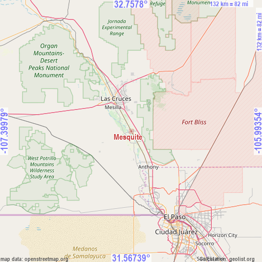
Mesquite GPS coordinates[2]
32° 9' 52.344" North, 106° 41' 47.976" West
| Map corner | latitude | longitude |
|---|---|---|
| Upper-left | 32.7578°, | -107.39979° |
| Center: | 32.16454°, | -106.69666° |
| Lower-right: | 31.56739°, | -105.99354° |
| Map W x H: | 132.4×132.4 km | = 82.3×82.3mi |
| max Lat: | 71.29058° ⇑88.2% North |
| Mesquite: | 32.16454° |
| min Lat: | ⇓11.8% South 19.06759° |
| min Long | Mesquite | max Long |
| -171.73463° | -106.69666° | -66.98998° |
| W 15.5%⇐ | ⇒84.5% E |
Elevation
Elevation of Mesquite is 1169 m = 3835 ft, and this is 874.2 m = 2868 ft above average elevation for this country.
| Max E: |
3189 m = 10463 ft | 5.6% |
| Mesquite | 1169 m 3835 ft | |
| Avg. | 294.8 m = 967 ft | |
Min E: |
-60 m = -197 ft | 94.4% |
See also: United States elevation on elevation.city.
Geographical zone
Mesquite is located in North temperate zone (between Tropic of Cancer and the Arctic Circle). Distance of this Northern Tropic circle is 970.4 km =603 mi to South.| Distance of | km | miles | from Mesquite |
|---|---|---|---|
| North Pole | 6430.7 | 3995.9 | to North |
| Arctic Circle | 3824.8 | 2376.6 | to North |
| Tropic Cancer | 970.4 | 603 | to South |
| Equator | 3576.4 | 2222.3 | to South |


Nearby cities:
15 places around Mesquite: (largest is in red/bold)
• Anthony
19.8 km =12.3 mi,  154°
154°
• Anthony
20.3 km =12.6 mi, 154°
• Berino
12.6 km =7.8 mi, 145°
• Chamberino
13.9 km =8.6 mi,  175°
175°
• Fairacres
21 km =13 mi,  317°
317°
• La Mesa
4.8 km =3 mi,  192°
192°
• La Union
24 km =14.9 mi,  172°
172°
• Las Cruces
18.1 km =11.2 mi,  334°
334°
• Mesilla
15.3 km =9.5 mi, 320°
• San Miguel
3.7 km =2.3 mi,  254°
254°
• San Pablo
11.9 km =7.4 mi, 322°
• San Ysidro
23.4 km =14.5 mi, 332°
• University Park
14.3 km =8.9 mi,  338°
338°
• Vado
6.7 km =4.2 mi, 151°
• Vinton
25.3 km =15.7 mi,  159°
159°
Sources, notices
• [Note1] Compared only with cities in United States existing in our database
• [Src1] Map data: © OpenStreetMap contributors (CC-BY-SA)
• [Src2] Other city data from geonames.org with taken over terms of usage.
• [Src3] Geographical zone / Annual Mean Temperature by Robert A. Rohde @ Wikipedia
