Vinton geodata
Vinton (Texas) is a populated place; located in United States in America/Denver (GMT-6) time zone. With population of 1,973 people, there are 12016 cities with bigger population in this country. Compared to other cities in United States, 88.7% of cities are located further ↑North; 84.4% of cities are located further →East and 94.3% of cities have lower elevation than Vinton. Note1


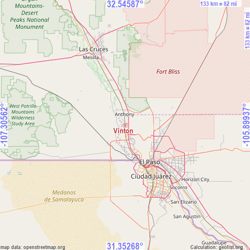
Vinton GPS coordinates[2]
31° 57' 4.356" North, 106° 36' 8.964" West
| Map corner | latitude | longitude |
|---|---|---|
| Upper-left | 32.54587°, | -107.30562° |
| Center: | 31.95121°, | -106.60249° |
| Lower-right: | 31.35268°, | -105.89937° |
| Map W x H: | 132.7×132.7 km | = 82.5×82.5mi |
| max Lat: | 71.29058° ⇑88.7% North |
| Vinton: | 31.95121° |
| min Lat: | ⇓11.3% South 19.06759° |
| min Long | Vinton | max Long |
| -171.73463° | -106.60249° | -66.98998° |
| W 15.6%⇐ | ⇒84.4% E |
Elevation
Elevation of Vinton is 1152 m = 3780 ft, and this is 857.2 m = 2812 ft above average elevation for this country.
| Max E: |
3189 m = 10463 ft | 5.7% |
| Vinton | 1152 m 3780 ft | |
| Avg. | 294.8 m = 967 ft | |
Min E: |
-60 m = -197 ft | 94.3% |
See also: United States elevation on elevation.city.
Geographical zone
Vinton is located in North temperate zone (between Tropic of Cancer and the Arctic Circle). Distance of this Northern Tropic circle is 946.7 km =588.3 mi to South.| Distance of | km | miles | from Vinton |
|---|---|---|---|
| North Pole | 6454.4 | 4010.6 | to North |
| Arctic Circle | 3848.5 | 2391.3 | to North |
| Tropic Cancer | 946.7 | 588.3 | to South |
| Equator | 3552.6 | 2207.5 | to South |


Nearby cities:
15 places around Vinton: (largest is in red/bold)
• Anthony
5.4 km =3.4 mi,  356°
356°
• Anthony
5.9 km =3.7 mi, 356°
• Berino
13.4 km =8.3 mi,  352°
352°
• Canutillo
4.4 km =2.7 mi,  177°
177°
• Chamberino
12.6 km =7.8 mi,  321°
321°
• Chaparral
22 km =13.7 mi,  68°
68°
• El Paso
24 km =14.9 mi,  152°
152°
• Fort Bliss
23.6 km =14.7 mi,  130°
130°
• La Mesa
21.4 km =13.3 mi,  332°
332°
• La Union
5.6 km =3.5 mi,  269°
269°
• Mesquite
25.3 km =15.7 mi,  339°
339°
• Santa Teresa
11.1 km =6.9 mi,  198°
198°
• Sunland Park
17.3 km =10.7 mi,  172°
172°
• Vado
18.7 km =11.6 mi, 342°
• Westway
2.5 km =1.6 mi, 70°
Sources, notices
• [Note1] Compared only with cities in United States existing in our database
• [Src1] Map data: © OpenStreetMap contributors (CC-BY-SA)
• [Src2] Other city data from geonames.org with taken over terms of usage.
• [Src3] Geographical zone / Annual Mean Temperature by Robert A. Rohde @ Wikipedia
