Sunland Park geodata
Sunland Park (New Mexico) is a populated place; located in United States in America/Denver (GMT-6) time zone. With population of 15,940 people, there are 3071 cities with bigger population in this country. Compared to other cities in United States, 89% of cities are located further ↑North; 84.4% of cities are located further →East and 94.3% of cities have lower elevation than Sunland Park. Note1


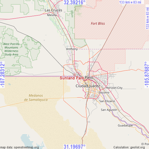
Sunland Park GPS coordinates[2]
31° 47' 47.4" North, 106° 34' 47.964" West
| Map corner | latitude | longitude |
|---|---|---|
| Upper-left | 32.39216°, | -107.28312° |
| Center: | 31.7965°, | -106.57999° |
| Lower-right: | 31.19697°, | -105.87687° |
| Map W x H: | 132.9×132.9 km | = 82.6×82.6mi |
| max Lat: | 71.29058° ⇑89% North |
| Sunland Park: | 31.7965° |
| min Lat: | ⇓11% South 19.06759° |
| min Long | Sunland Park | max Long |
| -171.73463° | -106.57999° | -66.98998° |
| W 15.6%⇐ | ⇒84.4% E |
Elevation
Elevation of Sunland Park is 1156 m = 3793 ft, and this is 861.2 m = 2825 ft above average elevation for this country.
| Max E: |
3189 m = 10463 ft | 5.7% |
| Sunland Park | 1156 m 3793 ft | |
| Avg. | 294.8 m = 967 ft | |
Min E: |
-60 m = -197 ft | 94.3% |
See also: United States elevation on elevation.city.
Geographical zone
Sunland Park is located in North temperate zone (between Tropic of Cancer and the Arctic Circle). Distance of this Northern Tropic circle is 929.5 km =577.6 mi to South.| Distance of | km | miles | from Sunland Park |
|---|---|---|---|
| North Pole | 6471.6 | 4021.3 | to North |
| Arctic Circle | 3865.7 | 2402 | to North |
| Tropic Cancer | 929.5 | 577.6 | to South |
| Equator | 3535.4 | 2196.8 | to South |


Nearby cities:
15 places around Sunland Park: (largest is in red/bold)
• Anthony
22.7 km =14.1 mi,  353°
353°
• Anthony
23.2 km =14.4 mi, 353°
• Berino
30.8 km =19.1 mi, 352°
• Canutillo
12.9 km =8 mi, 351°
• Chamberino
28.9 km =18 mi,  339°
339°
• Chaparral
31.2 km =19.4 mi,  35°
35°
• El Paso
9.7 km =6 mi,  115°
115°
• Fort Bliss
16 km =9.9 mi,  83°
83°
• La Union
18.8 km =11.7 mi, 335°
• Santa Teresa
8.7 km =5.4 mi,  319°
319°
• Socorro
30.6 km =19 mi, 121°
• Socorro Mission Number 1 Colonia
32.7 km =20.3 mi, 123°
• Sparks
35 km =21.7 mi,  113°
113°
• Vinton
17.3 km =10.7 mi, 352°
• Westway
18 km =11.2 mi,  0°
0°
Sources, notices
• [Note1] Compared only with cities in United States existing in our database
• [Src1] Map data: © OpenStreetMap contributors (CC-BY-SA)
• [Src2] Other city data from geonames.org with taken over terms of usage.
• [Src3] Geographical zone / Annual Mean Temperature by Robert A. Rohde @ Wikipedia
