El Paso geodata
El Paso (Texas) is a seat of a second-order administrative division; located in United States in America/Denver (GMT-6) time zone. With population of 681,124 people, there are 23 cities with bigger population in this country. Compared to other cities in United States, 89.1% of cities are located further ↑North; 84.3% of cities are located further →East and 94.2% of cities have lower elevation than El Paso. Note1


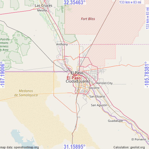
El Paso GPS coordinates[2]
31° 45' 31.392" North, 106° 29' 12.948" West
| Map corner | latitude | longitude |
|---|---|---|
| Upper-left | 32.35463°, | -107.19006° |
| Center: | 31.75872°, | -106.48693° |
| Lower-right: | 31.15895°, | -105.78381° |
| Map W x H: | 132.9×132.9 km | = 82.6×82.6mi |
| max Lat: | 71.29058° ⇑89.1% North |
| El Paso: | 31.75872° |
| min Lat: | ⇓10.9% South 19.06759° |
| min Long | El Paso | max Long |
| -171.73463° | -106.48693° | -66.98998° |
| W 15.7%⇐ | ⇒84.3% E |
Elevation
Elevation of El Paso is 1137 m = 3730 ft, and this is 842.2 m = 2763 ft above average elevation for this country.
| Max E: |
3189 m = 10463 ft | 5.8% |
| El Paso | 1137 m 3730 ft | |
| Avg. | 294.8 m = 967 ft | |
Min E: |
-60 m = -197 ft | 94.2% |
See also: El Paso elevation on elevation.city.
Geographical zone
El Paso is located in North temperate zone (between Tropic of Cancer and the Arctic Circle). Distance of this Northern Tropic circle is 925.3 km =575 mi to South.| Distance of | km | miles | from El Paso |
|---|---|---|---|
| North Pole | 6475.8 | 4023.9 | to North |
| Arctic Circle | 3869.9 | 2404.6 | to North |
| Tropic Cancer | 925.3 | 575 | to South |
| Equator | 3531.2 | 2194.2 | to South |


Nearby cities:
15 places around El Paso: (largest is in red/bold)
• Anthony
29 km =18 mi,  337°
337°
• Anthony
29.5 km =18.3 mi, 337°
• Canutillo
20.1 km =12.5 mi,  327°
327°
• Chaparral
31 km =19.3 mi,  17°
17°
• Fort Bliss
9.3 km =5.8 mi,  49°
49°
• Horizon City
27.4 km =17 mi,  105°
105°
• La Union
27 km =16.8 mi,  322°
322°
• San Elizario
28 km =17.4 mi,  133°
133°
• Santa Teresa
18 km =11.2 mi,  306°
306°
• Socorro
20.9 km =13 mi,  123°
123°
• Socorro Mission Number 1 Colonia
23 km =14.3 mi, 126°
• Sparks
25.3 km =15.7 mi, 112°
• Sunland Park
9.7 km =6 mi,  295°
295°
• Vinton
24 km =14.9 mi, 332°
• Westway
23.8 km =14.8 mi, 338°
Sources, notices
• [Note1] Compared only with cities in United States existing in our database
• [Src1] Map data: © OpenStreetMap contributors (CC-BY-SA)
• [Src2] Other city data from geonames.org with taken over terms of usage.
• [Src3] Geographical zone / Annual Mean Temperature by Robert A. Rohde @ Wikipedia
