Homestead Meadows North geodata
Homestead Meadows North (Texas) is a populated place; located in United States in America/Denver (GMT-6) time zone. With population of 5,124 people, there are 7060 cities with bigger population in this country. Compared to other cities in United States, 88.9% of cities are located further ↑North; 84.1% of cities are located further →East and 94.8% of cities have lower elevation than Homestead Meadows North. Note1
Current local time in Homestead Meadows North:
04:00 AM, TuesdayDifference from your time zone: hours


Homestead Meadows North GPS coordinates[2]
31° 50' 58.668" North, 106° 10' 22.26" West
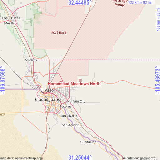
| Map corner | latitude | longitude |
|---|---|---|
| Upper-left | 32.44495°, | -106.87598° |
| Center: | 31.84963°, | -106.17285° |
| Lower-right: | 31.25044°, | -105.46973° |
| Map W x H: | 132.8×132.8 km | = 82.5×82.5mi |
| max Lat: | 71.29058° ⇑88.9% North |
| Homestead Meadows North: | 31.84963° |
| min Lat: | ⇓11.1% South 19.06759° |
| min Long | Homestead Meado | max Long |
| -171.73463° | -106.17285° | -66.98998° |
| W 15.9%⇐ | ⇒84.1% E |
Elevation
Elevation of Homestead Meadows North is 1236 m = 4055 ft, and this is 941.2 m = 3088 ft above average elevation for this country.
| Max E: |
3189 m = 10463 ft | 5.2% |
| Homestead Meadows North | 1236 m 4055 ft | |
| Avg. | 294.8 m = 967 ft | |
Min E: |
-60 m = -197 ft | 94.8% |
See also: United States elevation on elevation.city.
Geographical zone
Homestead Meadows North is located in North temperate zone (between Tropic of Cancer and the Arctic Circle). Distance of this Northern Tropic circle is 935.4 km =581.2 mi to South.| Distance of | km | miles | from Homestead Meadows North |
|---|---|---|---|
| North Pole | 6465.7 | 4017.6 | to North |
| Arctic Circle | 3859.8 | 2398.4 | to North |
| Tropic Cancer | 935.4 | 581.2 | to South |
| Equator | 3541.3 | 2200.5 | to South |


Nearby cities:
15 places around Homestead Meadows North: (largest is in red/bold)
• Agua Dulce
21.9 km =13.6 mi,  171°
171°
• Chaparral
27.9 km =17.3 mi,  313°
313°
• Clint
29 km =18 mi,  189°
189°
• El Paso
31.4 km =19.5 mi,  251°
251°
• Fabens
38.6 km =24 mi,  177°
177°
• Fort Bliss
23 km =14.3 mi,  259°
259°
• Homestead Meadows South
4.4 km =2.7 mi, 169°
• Horizon City
17.8 km =11.1 mi, 190°
• Morning Glory
31.3 km =19.4 mi, 187°
• San Elizario
30.9 km =19.2 mi,  197°
197°
• Socorro
25 km =15.5 mi,  209°
209°
• Socorro Mission Number 1 Colonia
26.2 km =16.3 mi, 205°
• Sparks
20.7 km =12.9 mi, 197°
• Sunland Park
38.9 km =24.2 mi, 261°
• Westway
40.1 km =24.9 mi,  287°
287°
Sources, notices
• [Note1] Compared only with cities in United States existing in our database
• [Src1] Map data: © OpenStreetMap contributors (CC-BY-SA)
• [Src2] Other city data from geonames.org with taken over terms of usage.
• [Src3] Geographical zone / Annual Mean Temperature by Robert A. Rohde @ Wikipedia
