Val Verde Park geodata
Val Verde Park (Texas) is a populated place; located in United States in America/Chicago (GMT-5) time zone. With population of 2,384 people, there are 10890 cities with bigger population in this country. Compared to other cities in United States, 94.8% of cities are located further ↑North; 81.2% of cities are located further →East and 77.2% of cities have lower elevation than Val Verde Park. Note1


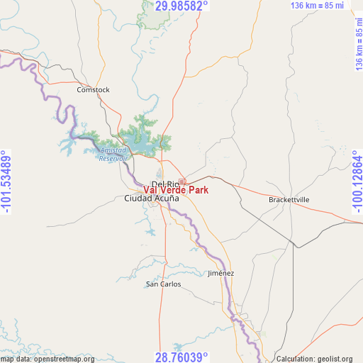
Val Verde Park GPS coordinates[2]
29° 22' 29.82" North, 100° 49' 54.336" West
| Map corner | latitude | longitude |
|---|---|---|
| Upper-left | 29.98582°, | -101.53489° |
| Center: | 29.37495°, | -100.83176° |
| Lower-right: | 28.76039°, | -100.12864° |
| Map W x H: | 136.3×136.3 km | = 84.7×84.7mi |
| max Lat: | 71.29058° ⇑94.8% North |
| Val Verde Park: | 29.37495° |
| min Lat: | ⇓5.2% South 19.06759° |
| min Long | Val Verde Park | max Long |
| -171.73463° | -100.83176° | -66.98998° |
| W 18.8%⇐ | ⇒81.2% E |
Elevation
Elevation of Val Verde Park is 329 m = 1079 ft, and this is 34.2 m = 112 ft above average elevation for this country.
| Max E: |
3189 m = 10463 ft | 22.8% |
| Val Verde Park | 329 m 1079 ft | |
| Avg. | 294.8 m = 967 ft | |
Min E: |
-60 m = -197 ft | 77.2% |
See also: United States elevation on elevation.city.
Geographical zone
Val Verde Park is located in North temperate zone (between Tropic of Cancer and the Arctic Circle). Distance of this Northern Tropic circle is 660.3 km =410.3 mi to South.| Distance of | km | miles | from Val Verde Park |
|---|---|---|---|
| North Pole | 6740.9 | 4188.6 | to North |
| Arctic Circle | 4135 | 2569.4 | to North |
| Tropic Cancer | 660.3 | 410.3 | to South |
| Equator | 3266.2 | 2029.5 | to South |


Nearby cities:
15 places around Val Verde Park: (largest is in red/bold)
• Brackettville
40.8 km =25.4 mi,  100°
100°
• Camp Wood
85.8 km =53.3 mi,  67°
67°
• Cienegas Terrace
10.9 km =6.8 mi,  265°
265°
• Del Rio
6.4 km =4 mi,  257°
257°
• Eagle Pass
80.8 km =50.2 mi,  156°
156°
• Eidson Road
84.5 km =52.5 mi, 156°
• Elm Creek
74.5 km =46.3 mi,  153°
153°
• Fort Clark Springs
40.4 km =25.1 mi, 100°
• Las Quintas Fronterizas
83.9 km =52.1 mi, 155°
• Las Quintas Fronterizas Colonia
83.8 km =52.1 mi, 155°
• Laughlin Air Force Base
5.1 km =3.2 mi,  113°
113°
• Radar Base
64.6 km =40.1 mi, 152°
• Rosita North
89.3 km =55.5 mi, 153°
• Seco Mines
77 km =47.8 mi, 155°
• Siesta Acres
76.2 km =47.3 mi, 154°
Sources, notices
• [Note1] Compared only with cities in United States existing in our database
• [Src1] Map data: © OpenStreetMap contributors (CC-BY-SA)
• [Src2] Other city data from geonames.org with taken over terms of usage.
• [Src3] Geographical zone / Annual Mean Temperature by Robert A. Rohde @ Wikipedia
