Camp Wood geodata
Camp Wood (Texas) is a populated place; located in United States in America/Chicago (GMT-5) time zone. With population of 701 people, there are 18667 cities with bigger population in this country. Compared to other cities in United States, 94.2% of cities are located further ↑North; 80.8% of cities are located further →East and 86.1% of cities have lower elevation than Camp Wood. Note1


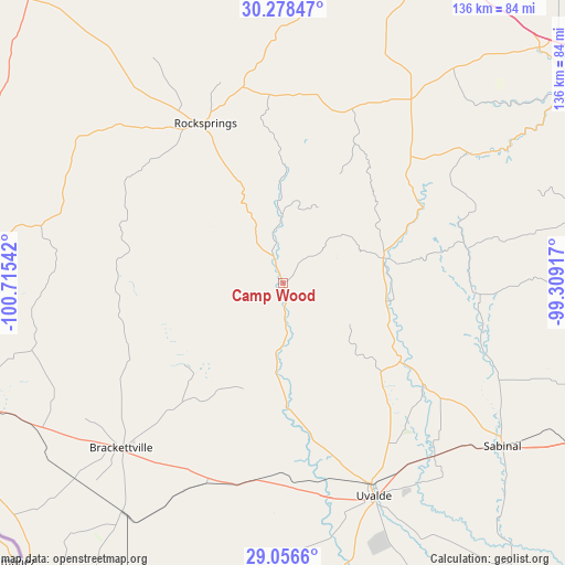
Camp Wood GPS coordinates[2]
29° 40' 9.804" North, 100° 0' 44.244" West
| Map corner | latitude | longitude |
|---|---|---|
| Upper-left | 30.27847°, | -100.71542° |
| Center: | 29.66939°, | -100.01229° |
| Lower-right: | 29.0566°, | -99.30917° |
| Map W x H: | 135.9×135.9 km | = 84.4×84.4mi |
| max Lat: | 71.29058° ⇑94.2% North |
| Camp Wood: | 29.66939° |
| min Lat: | ⇓5.8% South 19.06759° |
| min Long | Camp Wood | max Long |
| -171.73463° | -100.01229° | -66.98998° |
| W 19.2%⇐ | ⇒80.8% E |
Elevation
Elevation of Camp Wood is 445 m = 1460 ft, and this is 150.2 m = 493 ft above average elevation for this country.
| Max E: |
3189 m = 10463 ft | 13.9% |
| Camp Wood | 445 m 1460 ft | |
| Avg. | 294.8 m = 967 ft | |
Min E: |
-60 m = -197 ft | 86.1% |
See also: United States elevation on elevation.city.
Geographical zone
Camp Wood is located in North temperate zone (between Tropic of Cancer and the Arctic Circle). Distance of this Northern Tropic circle is 693 km =430.6 mi to South.| Distance of | km | miles | from Camp Wood |
|---|---|---|---|
| North Pole | 6708.1 | 4168.2 | to North |
| Arctic Circle | 4102.2 | 2549 | to North |
| Tropic Cancer | 693 | 430.6 | to South |
| Equator | 3298.9 | 2049.8 | to South |


Nearby cities:
15 places around Camp Wood: (largest is in red/bold)
• Batesville
88.6 km =55.1 mi,  154°
154°
• Brackettville
56 km =34.8 mi,  224°
224°
• D'Hanis
80.3 km =49.9 mi,  117°
117°
• Fort Clark Springs
56.6 km =35.2 mi, 224°
• Ingram
87.2 km =54.2 mi,  58°
58°
• Knippa
55.2 km =34.3 mi,  138°
138°
• La Pryor
82.5 km =51.3 mi,  168°
168°
• Laughlin Air Force Base
82.3 km =51.1 mi,  245°
245°
• Leakey
25.1 km =15.6 mi,  74°
74°
• Medina
75.3 km =46.8 mi,  79°
79°
• Rocksprings
42.8 km =26.6 mi,  334°
334°
• Sabinal
65.7 km =40.8 mi,  126°
126°
• Uvalde
55.6 km =34.5 mi,  156°
156°
• Uvalde Estates
58.7 km =36.5 mi, 162°
• Val Verde Park
85.8 km =53.3 mi, 247°
Sources, notices
• [Note1] Compared only with cities in United States existing in our database
• [Src1] Map data: © OpenStreetMap contributors (CC-BY-SA)
• [Src2] Other city data from geonames.org with taken over terms of usage.
• [Src3] Geographical zone / Annual Mean Temperature by Robert A. Rohde @ Wikipedia
