Beatty geodata
Beatty (Nevada) is a populated place; located in United States in America/Los_Angeles (GMT-7) time zone. With population of 1,010 people, there are 16223 cities with bigger population in this country. Compared to other cities in United States, 66.6% of cities are located further ↑North; 89.5% of cities are located further →East and 93.5% of cities have lower elevation than Beatty. Note1


Beatty GPS coordinates[2]
36° 54' 30.816" North, 116° 45' 33.228" West
| Map corner | latitude | longitude |
|---|---|---|
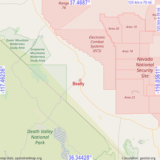
| Upper-left | 37.4687°, | -117.46236° |
| Center: | 36.90856°, | -116.75923° |
| Lower-right: | 36.34428°, | -116.05611° |
| Map W x H: | 125×125 km | = 77.7×77.7mi |
| max Lat: | 71.29058° ⇑66.6% North |
| Beatty: | 36.90856° |
| min Lat: | ⇓33.4% South 19.06759° |
| min Long | Beatty | max Long |
| -171.73463° | -116.75923° | -66.98998° |
| W 10.5%⇐ | ⇒89.5% E |
Elevation
Elevation of Beatty is 1011 m = 3317 ft, and this is 716.2 m = 2350 ft above average elevation for this country.
| Max E: |
3189 m = 10463 ft | 6.5% |
| Beatty | 1011 m 3317 ft | |
| Avg. | 294.8 m = 967 ft | |
Min E: |
-60 m = -197 ft | 93.5% |
See also: United States elevation on elevation.city.
Geographical zone
Beatty is located in North temperate zone (between Tropic of Cancer and the Arctic Circle). Distance of this Northern Tropic circle is 1497.9 km =930.8 mi to South.| Distance of | km | miles | from Beatty |
|---|---|---|---|
| North Pole | 5903.2 | 3668.1 | to North |
| Arctic Circle | 3297.3 | 2048.8 | to North |
| Tropic Cancer | 1497.9 | 930.8 | to South |
| Equator | 4103.8 | 2550 | to South |


Nearby cities:
15 places around Beatty: (largest is in red/bold)
• Alamo
150.2 km =93.3 mi,  70°
70°
• Big Pine
138.8 km =86.2 mi,  281°
281°
• Bishop
153.6 km =95.4 mi,  289°
289°
• Dixon Lane-Meadow Creek
156.1 km =97 mi, 289°
• Goldfield
98.4 km =61.1 mi,  334°
334°
• Independence
128.7 km =80 mi,  264°
264°
• Indian Springs
104.1 km =64.7 mi,  111°
111°
• Lone Pine
121 km =75.2 mi,  253°
253°
• Pahrump
104.2 km =64.7 mi,  138°
138°
• Sandy Valley
157.8 km =98.1 mi, 140°
• Searles Valley
139.4 km =86.6 mi,  204°
204°
• Summerlin South
155.1 km =96.4 mi,  124°
124°
• Tonopah
135.4 km =84.1 mi,  342°
342°
• West Bishop
158.5 km =98.5 mi, 288°
• Wilkerson
150.2 km =93.3 mi, 285°
Sources, notices
• [Note1] Compared only with cities in United States existing in our database
• [Src1] Map data: © OpenStreetMap contributors (CC-BY-SA)
• [Src2] Other city data from geonames.org with taken over terms of usage.
• [Src3] Geographical zone / Annual Mean Temperature by Robert A. Rohde @ Wikipedia
