Sandy Valley geodata
Sandy Valley (Nevada) is a populated place; located in United States in America/Los_Angeles (GMT-7) time zone. With population of 2,051 people, there are 11787 cities with bigger population in this country. Compared to other cities in United States, 71.2% of cities are located further ↑North; 89.1% of cities are located further →East and 92.1% of cities have lower elevation than Sandy Valley. Note1


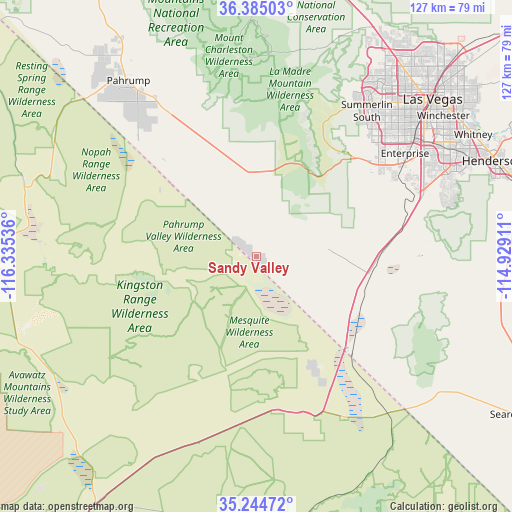
Sandy Valley GPS coordinates[2]
35° 49' 0.912" North, 115° 37' 56.028" West
| Map corner | latitude | longitude |
|---|---|---|
| Upper-left | 36.38503°, | -116.33536° |
| Center: | 35.81692°, | -115.63223° |
| Lower-right: | 35.24472°, | -114.92911° |
| Map W x H: | 126.8×126.8 km | = 78.8×78.8mi |
| max Lat: | 71.29058° ⇑71.2% North |
| Sandy Valley: | 35.81692° |
| min Lat: | ⇓28.8% South 19.06759° |
| min Long | Sandy Valley | max Long |
| -171.73463° | -115.63223° | -66.98998° |
| W 10.9%⇐ | ⇒89.1% E |
Elevation
Elevation of Sandy Valley is 806 m = 2644 ft, and this is 511.2 m = 1677 ft above average elevation for this country.
| Max E: |
3189 m = 10463 ft | 7.9% |
| Sandy Valley | 806 m 2644 ft | |
| Avg. | 294.8 m = 967 ft | |
Min E: |
-60 m = -197 ft | 92.1% |
See also: United States elevation on elevation.city.
Geographical zone
Sandy Valley is located in North temperate zone (between Tropic of Cancer and the Arctic Circle). Distance of this Northern Tropic circle is 1376.5 km =855.3 mi to South.| Distance of | km | miles | from Sandy Valley |
|---|---|---|---|
| North Pole | 6024.6 | 3743.5 | to North |
| Arctic Circle | 3418.7 | 2124.3 | to North |
| Tropic Cancer | 1376.5 | 855.3 | to South |
| Equator | 3982.5 | 2474.6 | to South |


Nearby cities:
15 places around Sandy Valley: (largest is in red/bold)
• Baker
73.3 km =45.5 mi,  213°
213°
• Boulder City
74.2 km =46.1 mi,  75°
75°
• Enterprise
42.1 km =26.2 mi,  56°
56°
• Henderson
63.6 km =39.5 mi,  67°
67°
• Las Vegas
59.7 km =37.1 mi,  48°
48°
• Nellis Air Force Base
70.4 km =43.7 mi, 47°
• North Las Vegas
62.8 km =39 mi, 47°
• Pahrump
53.8 km =33.4 mi,  323°
323°
• Paradise
53.7 km =33.4 mi, 54°
• Searchlight
75.3 km =46.8 mi,  121°
121°
• Spring Valley
47.6 km =29.6 mi, 47°
• Summerlin South
43.1 km =26.8 mi,  39°
39°
• Sunrise Manor
66.7 km =41.4 mi, 48°
• Whitney
62.1 km =38.6 mi, 59°
• Winchester
57.8 km =35.9 mi, 53°
Sources, notices
• [Note1] Compared only with cities in United States existing in our database
• [Src1] Map data: © OpenStreetMap contributors (CC-BY-SA)
• [Src2] Other city data from geonames.org with taken over terms of usage.
• [Src3] Geographical zone / Annual Mean Temperature by Robert A. Rohde @ Wikipedia
