Dixon Lane-Meadow Creek geodata
Dixon Lane-Meadow Creek (California) is a populated place; located in United States in America/Los_Angeles (GMT-7) time zone. With population of 2,645 people, there are 10296 cities with bigger population in this country. Compared to other cities in United States, 64.5% of cities are located further ↑North; 91.5% of cities are located further →East and 95.1% of cities have lower elevation than Dixon Lane-Meadow Creek. Note1
Current local time in Dixon Lane-Meadow Creek:
01:19 PM, TuesdayDifference from your time zone: hours


Dixon Lane-Meadow Creek GPS coordinates[2]
37° 23' 11.004" North, 118° 24' 54.972" West
| Map corner | latitude | longitude |
|---|---|---|
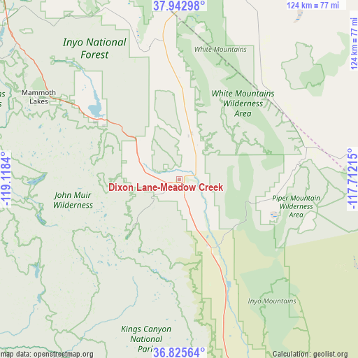
| Upper-left | 37.94298°, | -119.1184° |
| Center: | 37.38639°, | -118.41527° |
| Lower-right: | 36.82564°, | -117.71215° |
| Map W x H: | 124.2×124.2 km | = 77.2×77.2mi |
| max Lat: | 71.29058° ⇑64.5% North |
| Dixon Lane-Meadow Creek: | 37.38639° |
| min Lat: | ⇓35.5% South 19.06759° |
| min Long | Dixon Lane-Mead | max Long |
| -171.73463° | -118.41527° | -66.98998° |
| W 8.5%⇐ | ⇒91.5% E |
Elevation
Elevation of Dixon Lane-Meadow Creek is 1274 m = 4180 ft, and this is 979.2 m = 3213 ft above average elevation for this country.
| Max E: |
3189 m = 10463 ft | 4.9% |
| Dixon Lane-Meadow Creek | 1274 m 4180 ft | |
| Avg. | 294.8 m = 967 ft | |
Min E: |
-60 m = -197 ft | 95.1% |
See also: United States elevation on elevation.city.
Geographical zone
Dixon Lane-Meadow Creek is located in North temperate zone (between Tropic of Cancer and the Arctic Circle). Distance of this Northern Tropic circle is 1551.1 km =963.8 mi to South.| Distance of | km | miles | from Dixon Lane-Meadow Creek |
|---|---|---|---|
| North Pole | 5850.1 | 3635.1 | to North |
| Arctic Circle | 3244.2 | 2015.9 | to North |
| Tropic Cancer | 1551.1 | 963.8 | to South |
| Equator | 4157 | 2583 | to South |


Nearby cities:
15 places around Dixon Lane-Meadow Creek: (largest is in red/bold)
• Auberry
100.6 km =62.5 mi,  250°
250°
• Bass Lake
102 km =63.4 mi,  266°
266°
• Big Pine
27 km =16.8 mi,  155°
155°
• Bishop
3.1 km =1.9 mi,  144°
144°
• Goldfield
110 km =68.4 mi,  70°
70°
• Independence
67.6 km =42 mi, 163°
• June Lake
72.8 km =45.2 mi,  306°
306°
• Lone Pine
92.2 km =57.3 mi, 160°
• Mammoth Lakes
57.1 km =35.5 mi,  300°
300°
• Oakhurst
109.3 km =67.9 mi, 266°
• Shaver Lake
85.8 km =53.3 mi, 248°
• Squaw Valley
103 km =64 mi,  225°
225°
• West Bishop
4.5 km =2.8 mi, 231°
• Wilkerson
12.1 km =7.5 mi,  168°
168°
• Yosemite Valley
109.8 km =68.2 mi,  291°
291°
Sources, notices
• [Note1] Compared only with cities in United States existing in our database
• [Src1] Map data: © OpenStreetMap contributors (CC-BY-SA)
• [Src2] Other city data from geonames.org with taken over terms of usage.
• [Src3] Geographical zone / Annual Mean Temperature by Robert A. Rohde @ Wikipedia
