Westhaven-Moonstone geodata
Westhaven-Moonstone (California) is a populated place; located in United States in America/Los_Angeles (GMT-7) time zone. With population of 1,205 people, there are 15100 cities with bigger population in this country. Compared to other cities in United States, 66.4% of cities are located further ↓South; 98.6% of cities are located further →East and 59.9% of cities have higher elevation than Westhaven-Moonstone. Note1


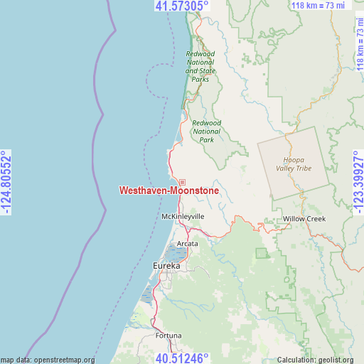
Westhaven-Moonstone GPS coordinates[2]
41° 2' 41.604" North, 124° 6' 8.604" West
| Map corner | latitude | longitude |
|---|---|---|
| Upper-left | 41.57305°, | -124.80552° |
| Center: | 41.04489°, | -124.10239° |
| Lower-right: | 40.51246°, | -123.39927° |
| Map W x H: | 117.9×117.9 km | = 73.3×73.3mi |
| max Lat: | 71.29058° ⇑33.6% North |
| Westhaven-Moonstone: | 41.04489° |
| min Lat: | ⇓66.4% South 19.06759° |
| min Long | Westhaven-Moons | max Long |
| -171.73463° | -124.10239° | -66.98998° |
| W 1.4%⇐ | ⇒98.6% E |
Elevation
Elevation of Westhaven-Moonstone is 155 m = 509 ft, and this is 139.8 m = 459 ft below average elevation for this country.
| Max E: |
3189 m = 10463 ft | 59.9% |
| Avg. | 294.8 m = 967 ft | |
| Westhaven-Moonstone | 155 m = 509 ft | |
Min E: |
-60 m = -197 ft | 40.1% |
See also: United States elevation on elevation.city.
Geographical zone
Westhaven-Moonstone is located in North temperate zone (between Tropic of Cancer and the Arctic Circle). Distance of this Northern Tropic circle is 1957.8 km =1216.5 mi to South.| Distance of | km | miles | from Westhaven-Moonstone |
|---|---|---|---|
| North Pole | 5443.3 | 3382.3 | to North |
| Arctic Circle | 2837.4 | 1763.1 | to North |
| Tropic Cancer | 1957.8 | 1216.5 | to South |
| Equator | 4563.8 | 2835.8 | to South |


Nearby cities:
15 places around Westhaven-Moonstone: (largest is in red/bold)
• Arcata
19.9 km =12.4 mi,  175°
175°
• Bayside
22.8 km =14.2 mi,  171°
171°
• Bayview
31 km =19.3 mi,  192°
192°
• Blue Lake
20.6 km =12.8 mi,  151°
151°
• Cutten
30.8 km =19.1 mi, 186°
• Eureka
27.5 km =17.1 mi, 190°
• Fieldbrook
10.4 km =6.5 mi, 147°
• Humboldt Hill
36.2 km =22.5 mi, 191°
• Indianola
25.9 km =16.1 mi, 176°
• Indianola
41.4 km =25.7 mi,  195°
195°
• Manila
22.1 km =13.7 mi, 193°
• McKinleyville
10.9 km =6.8 mi, 179°
• Myrtletown
28.6 km =17.8 mi, 184°
• Pine Hills
34.9 km =21.7 mi, 186°
• Willow Creek
41.2 km =25.6 mi,  106°
106°
Sources, notices
• [Note1] Compared only with cities in United States existing in our database
• [Src1] Map data: © OpenStreetMap contributors (CC-BY-SA)
• [Src2] Other city data from geonames.org with taken over terms of usage.
• [Src3] Geographical zone / Annual Mean Temperature by Robert A. Rohde @ Wikipedia
