Ault geodata
Ault (Colorado) is a populated place; located in United States in America/Denver (GMT-6) time zone. With population of 1,622 people, there are 13209 cities with bigger population in this country. Compared to other cities in United States, 59.8% of cities are located further ↓South; 82.9% of cities are located further →East and 96.7% of cities have lower elevation than Ault. Note1


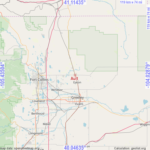
Ault GPS coordinates[2]
40° 34' 56.928" North, 104° 43' 54.876" West
| Map corner | latitude | longitude |
|---|---|---|
| Upper-left | 41.11435°, | -105.43504° |
| Center: | 40.58248°, | -104.73191° |
| Lower-right: | 40.04635°, | -104.02879° |
| Map W x H: | 118.8×118.7 km | = 73.8×73.8mi |
| max Lat: | 71.29058° ⇑40.2% North |
| Ault: | 40.58248° |
| min Lat: | ⇓59.8% South 19.06759° |
| min Long | Ault | max Long |
| -171.73463° | -104.73191° | -66.98998° |
| W 17.1%⇐ | ⇒82.9% E |
Elevation
Elevation of Ault is 1508 m = 4948 ft, and this is 1213.2 m = 3980 ft above average elevation for this country.
| Max E: |
3189 m = 10463 ft | 3.3% |
| Ault | 1508 m 4948 ft | |
| Avg. | 294.8 m = 967 ft | |
Min E: |
-60 m = -197 ft | 96.7% |
See also: United States elevation on elevation.city.
Geographical zone
Ault is located in North temperate zone (between Tropic of Cancer and the Arctic Circle). Distance of this Northern Tropic circle is 1906.4 km =1184.6 mi to South.| Distance of | km | miles | from Ault |
|---|---|---|---|
| North Pole | 5494.7 | 3414.2 | to North |
| Arctic Circle | 2888.8 | 1795 | to North |
| Tropic Cancer | 1906.4 | 1184.6 | to South |
| Equator | 4512.3 | 2803.8 | to South |


Nearby cities:
15 places around Ault: (largest is in red/bold)
• Eaton
6.1 km =3.8 mi,  163°
163°
• Evans
23.2 km =14.4 mi,  171°
171°
• Fort Collins
29.8 km =18.5 mi,  270°
270°
• Gilcrest
33.6 km =20.9 mi,  186°
186°
• Greeley
17.8 km =11.1 mi, 173°
• Johnstown
31.3 km =19.4 mi,  209°
209°
• Kersey
26 km =16.2 mi,  146°
146°
• La Salle
26.1 km =16.2 mi, 174°
• Laporte
34.7 km =21.6 mi,  278°
278°
• Milliken
30 km =18.6 mi,  200°
200°
• Pierce
6.2 km =3.9 mi,  341°
341°
• Severance
12 km =7.5 mi,  237°
237°
• Timnath
22.2 km =13.8 mi,  254°
254°
• Wellington
27 km =16.8 mi,  300°
300°
• Windsor
18.5 km =11.5 mi,  230°
230°
Sources, notices
• [Note1] Compared only with cities in United States existing in our database
• [Src1] Map data: © OpenStreetMap contributors (CC-BY-SA)
• [Src2] Other city data from geonames.org with taken over terms of usage.
• [Src3] Geographical zone / Annual Mean Temperature by Robert A. Rohde @ Wikipedia
