Timnath geodata
Timnath (Colorado) is a populated place; located in United States in America/Denver (GMT-6) time zone. With population of 625 people, there are 19413 cities with bigger population in this country. Compared to other cities in United States, 59.2% of cities are located further ↓South; 83.3% of cities are located further →East and 96.6% of cities have lower elevation than Timnath. Note1


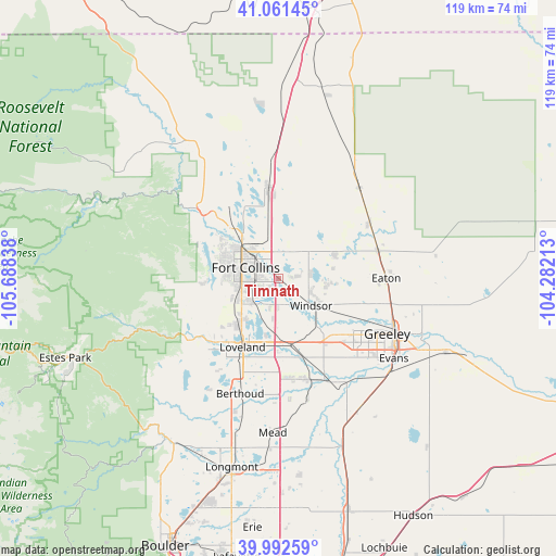
Timnath GPS coordinates[2]
40° 31' 44.94" North, 104° 59' 6.9" West
| Map corner | latitude | longitude |
|---|---|---|
| Upper-left | 41.06145°, | -105.68838° |
| Center: | 40.52915°, | -104.98525° |
| Lower-right: | 39.99259°, | -104.28213° |
| Map W x H: | 118.8×118.8 km | = 73.8×73.8mi |
| max Lat: | 71.29058° ⇑40.8% North |
| Timnath: | 40.52915° |
| min Lat: | ⇓59.2% South 19.06759° |
| min Long | Timnath | max Long |
| -171.73463° | -104.98525° | -66.98998° |
| W 16.7%⇐ | ⇒83.3% E |
Elevation
Elevation of Timnath is 1485 m = 4872 ft, and this is 1190.2 m = 3905 ft above average elevation for this country.
| Max E: |
3189 m = 10463 ft | 3.4% |
| Timnath | 1485 m 4872 ft | |
| Avg. | 294.8 m = 967 ft | |
Min E: |
-60 m = -197 ft | 96.6% |
See also: United States elevation on elevation.city.
Geographical zone
Timnath is located in North temperate zone (between Tropic of Cancer and the Arctic Circle). Distance of this Northern Tropic circle is 1900.5 km =1180.9 mi to South.| Distance of | km | miles | from Timnath |
|---|---|---|---|
| North Pole | 5500.6 | 3417.9 | to North |
| Arctic Circle | 2894.8 | 1798.7 | to North |
| Tropic Cancer | 1900.5 | 1180.9 | to South |
| Equator | 4506.4 | 2800.1 | to South |


Nearby cities:
15 places around Timnath: (largest is in red/bold)
• Ault
22.2 km =13.8 mi,  74°
74°
• Berthoud
25.9 km =16.1 mi,  198°
198°
• Campion
21.5 km =13.4 mi, 201°
• Eaton
23.1 km =14.4 mi,  89°
89°
• Evans
30.1 km =18.7 mi,  124°
124°
• Fort Collins
10.4 km =6.5 mi,  306°
306°
• Greeley
26.2 km =16.3 mi, 116°
• Johnstown
22.2 km =13.8 mi,  163°
163°
• Laporte
16.9 km =10.5 mi, 309°
• Loveland
16.5 km =10.3 mi,  207°
207°
• Milliken
24.8 km =15.4 mi,  153°
153°
• Pierce
22.7 km =14.1 mi,  58°
58°
• Severance
11.4 km =7.1 mi, 92°
• Wellington
19.5 km =12.1 mi,  354°
354°
• Windsor
9.1 km =5.7 mi,  129°
129°
Sources, notices
• [Note1] Compared only with cities in United States existing in our database
• [Src1] Map data: © OpenStreetMap contributors (CC-BY-SA)
• [Src2] Other city data from geonames.org with taken over terms of usage.
• [Src3] Geographical zone / Annual Mean Temperature by Robert A. Rohde @ Wikipedia
