Craig geodata
Craig (Colorado) is a seat of a second-order administrative division; located in United States in America/Denver (GMT-6) time zone. With population of 8,844 people, there are 4863 cities with bigger population in this country. Compared to other cities in United States, 59.1% of cities are located further ↓South; 84.8% of cities are located further →East and 98.7% of cities have lower elevation than Craig. Note1


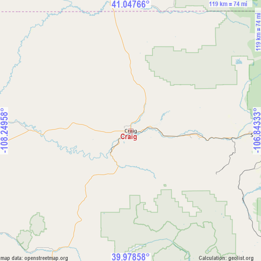
Craig GPS coordinates[2]
40° 30' 54.9" North, 107° 32' 47.22" West
| Map corner | latitude | longitude |
|---|---|---|
| Upper-left | 41.04766°, | -108.24958° |
| Center: | 40.51525°, | -107.54645° |
| Lower-right: | 39.97858°, | -106.84333° |
| Map W x H: | 118.9×118.9 km | = 73.9×73.9mi |
| max Lat: | 71.29058° ⇑40.9% North |
| Craig: | 40.51525° |
| min Lat: | ⇓59.1% South 19.06759° |
| min Long | Craig | max Long |
| -171.73463° | -107.54645° | -66.98998° |
| W 15.2%⇐ | ⇒84.8% E |
Elevation
Elevation of Craig is 1891 m = 6204 ft, and this is 1596.2 m = 5237 ft above average elevation for this country.
| Max E: |
3189 m = 10463 ft | 1.3% |
| Craig | 1891 m 6204 ft | |
| Avg. | 294.8 m = 967 ft | |
Min E: |
-60 m = -197 ft | 98.7% |
See also: United States elevation on elevation.city.
Geographical zone
Craig is located in North temperate zone (between Tropic of Cancer and the Arctic Circle). Distance of this Northern Tropic circle is 1899 km =1180 mi to South.| Distance of | km | miles | from Craig |
|---|---|---|---|
| North Pole | 5502.2 | 3418.9 | to North |
| Arctic Circle | 2896.3 | 1799.7 | to North |
| Tropic Cancer | 1899 | 1180 | to South |
| Equator | 4504.9 | 2799.2 | to South |


Nearby cities:
15 places around Craig: (largest is in red/bold)
• Cattle Creek
120 km =74.6 mi,  168°
168°
• Dotsero
104.7 km =65.1 mi,  156°
156°
• Eagle
113.5 km =70.5 mi,  147°
147°
• Glenwood Springs
108.9 km =67.7 mi, 170°
• Gypsum
109 km =67.7 mi, 152°
• Hayden
24.5 km =15.2 mi,  95°
95°
• Kremmling
110.5 km =68.7 mi,  117°
117°
• Meeker
61.6 km =38.3 mi,  210°
210°
• New Castle
104.8 km =65.1 mi,  179°
179°
• Oak Creek
56.5 km =35.1 mi, 118°
• Rangely
116.8 km =72.6 mi,  245°
245°
• Rifle
110.9 km =68.9 mi,  190°
190°
• Silt
107.9 km =67 mi, 184°
• Steamboat Springs
60.5 km =37.6 mi,  93°
93°
• Walden
109.3 km =67.9 mi,  77°
77°
Sources, notices
• [Note1] Compared only with cities in United States existing in our database
• [Src1] Map data: © OpenStreetMap contributors (CC-BY-SA)
• [Src2] Other city data from geonames.org with taken over terms of usage.
• [Src3] Geographical zone / Annual Mean Temperature by Robert A. Rohde @ Wikipedia
