Rifle geodata
Rifle (Colorado) is a populated place; located in United States in America/Denver (GMT-6) time zone. With population of 9,563 people, there are 4600 cities with bigger population in this country. Compared to other cities in United States, 50.6% of cities are located further ↑North; 84.9% of cities are located further →East and 97.6% of cities have lower elevation than Rifle. Note1


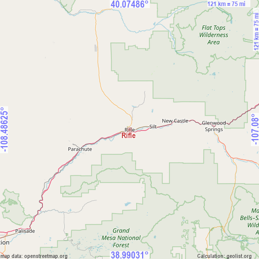
Rifle GPS coordinates[2]
39° 32' 4.92" North, 107° 46' 59.232" West
| Map corner | latitude | longitude |
|---|---|---|
| Upper-left | 40.07486°, | -108.48625° |
| Center: | 39.5347°, | -107.78312° |
| Lower-right: | 38.99031°, | -107.08° |
| Map W x H: | 120.6×120.6 km | = 74.9×74.9mi |
| max Lat: | 71.29058° ⇑50.6% North |
| Rifle: | 39.5347° |
| min Lat: | ⇓49.4% South 19.06759° |
| min Long | Rifle | max Long |
| -171.73463° | -107.78312° | -66.98998° |
| W 15.1%⇐ | ⇒84.9% E |
Elevation
Elevation of Rifle is 1637 m = 5371 ft, and this is 1342.2 m = 4404 ft above average elevation for this country.
| Max E: |
3189 m = 10463 ft | 2.4% |
| Rifle | 1637 m 5371 ft | |
| Avg. | 294.8 m = 967 ft | |
Min E: |
-60 m = -197 ft | 97.6% |
See also: United States elevation on elevation.city.
Geographical zone
Rifle is located in North temperate zone (between Tropic of Cancer and the Arctic Circle). Distance of this Northern Tropic circle is 1789.9 km =1112.2 mi to South.| Distance of | km | miles | from Rifle |
|---|---|---|---|
| North Pole | 5611.2 | 3486.6 | to North |
| Arctic Circle | 3005.3 | 1867.4 | to North |
| Tropic Cancer | 1789.9 | 1112.2 | to South |
| Equator | 4395.8 | 2731.4 | to South |


Nearby cities:
15 places around Rifle: (largest is in red/bold)
• Basalt
67 km =41.6 mi,  105°
105°
• Battlement Mesa
23.2 km =14.4 mi,  243°
243°
• Carbondale
51.3 km =31.9 mi, 106°
• Cattle Creek
45.5 km =28.3 mi,  100°
100°
• Cedaredge
71.5 km =44.4 mi,  189°
189°
• Collbran
36.1 km =22.4 mi,  205°
205°
• Dotsero
63.2 km =39.3 mi,  78°
78°
• El Jebel
61.5 km =38.2 mi, 104°
• Glenwood Springs
39.3 km =24.4 mi,  87°
87°
• Gypsum
72.3 km =44.9 mi, 80°
• Meeker
57 km =35.4 mi,  348°
348°
• New Castle
21.6 km =13.4 mi, 78°
• Palisade
67.9 km =42.2 mi,  225°
225°
• Parachute
24.9 km =15.5 mi,  248°
248°
• Silt
11 km =6.8 mi, 81°
Sources, notices
• [Note1] Compared only with cities in United States existing in our database
• [Src1] Map data: © OpenStreetMap contributors (CC-BY-SA)
• [Src2] Other city data from geonames.org with taken over terms of usage.
• [Src3] Geographical zone / Annual Mean Temperature by Robert A. Rohde @ Wikipedia
