Walden geodata
Walden (Colorado) is a seat of a second-order administrative division; located in United States in America/Denver (GMT-6) time zone. With population of 584 people, there are 19867 cities with bigger population in this country. Compared to other cities in United States, 62.1% of cities are located further ↓South; 84.2% of cities are located further →East and 99.8% of cities have lower elevation than Walden. Note1


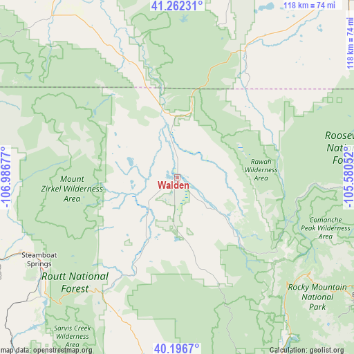
Walden GPS coordinates[2]
40° 43' 53.904" North, 106° 17' 1.104" West
| Map corner | latitude | longitude |
|---|---|---|
| Upper-left | 41.26231°, | -106.98677° |
| Center: | 40.73164°, | -106.28364° |
| Lower-right: | 40.1967°, | -105.58052° |
| Map W x H: | 118.5×118.5 km | = 73.6×73.6mi |
| max Lat: | 71.29058° ⇑37.9% North |
| Walden: | 40.73164° |
| min Lat: | ⇓62.1% South 19.06759° |
| min Long | Walden | max Long |
| -171.73463° | -106.28364° | -66.98998° |
| W 15.8%⇐ | ⇒84.2% E |
Elevation
Elevation of Walden is 2472 m = 8110 ft, and this is 2177.2 m = 7143 ft above average elevation for this country.
| Max E: |
3189 m = 10463 ft | 0.2% |
| Walden | 2472 m 8110 ft | |
| Avg. | 294.8 m = 967 ft | |
Min E: |
-60 m = -197 ft | 99.8% |
See also: United States elevation on elevation.city.
Geographical zone
Walden is located in North temperate zone (between Tropic of Cancer and the Arctic Circle). Distance of this Northern Tropic circle is 1923 km =1194.9 mi to South.| Distance of | km | miles | from Walden |
|---|---|---|---|
| North Pole | 5478.1 | 3403.9 | to North |
| Arctic Circle | 2872.2 | 1784.7 | to North |
| Tropic Cancer | 1923 | 1194.9 | to South |
| Equator | 4528.9 | 2814.1 | to South |


Nearby cities:
15 places around Walden: (largest is in red/bold)
• Allenspark
87.6 km =54.4 mi,  132°
132°
• Estes Park
75.5 km =46.9 mi,  121°
121°
• Fort Collins
102.5 km =63.7 mi,  99°
99°
• Fraser
96 km =59.7 mi,  155°
155°
• Granby
77.5 km =48.2 mi, 157°
• Hayden
86.3 km =53.6 mi,  252°
252°
• Hot Sulphur Springs
74.8 km =46.5 mi,  168°
168°
• Kremmling
75.3 km =46.8 mi,  186°
186°
• Laporte
97.2 km =60.4 mi, 96°
• Laramie
86.8 km =53.9 mi,  42°
42°
• Lyons
102.5 km =63.7 mi, 123°
• Oak Creek
76.4 km =47.5 mi,  228°
228°
• Saratoga
91.6 km =56.9 mi,  331°
331°
• Steamboat Springs
53.8 km =33.4 mi,  239°
239°
• Winter Park
103.3 km =64.2 mi,  154°
154°
Sources, notices
• [Note1] Compared only with cities in United States existing in our database
• [Src1] Map data: © OpenStreetMap contributors (CC-BY-SA)
• [Src2] Other city data from geonames.org with taken over terms of usage.
• [Src3] Geographical zone / Annual Mean Temperature by Robert A. Rohde @ Wikipedia
