Fort Lupton geodata
Fort Lupton (Colorado) is a populated place; located in United States in America/Denver (GMT-6) time zone. With population of 7,822 people, there are 5371 cities with bigger population in this country. Compared to other cities in United States, 54.4% of cities are located further ↓South; 83% of cities are located further →East and 96.7% of cities have lower elevation than Fort Lupton. Note1


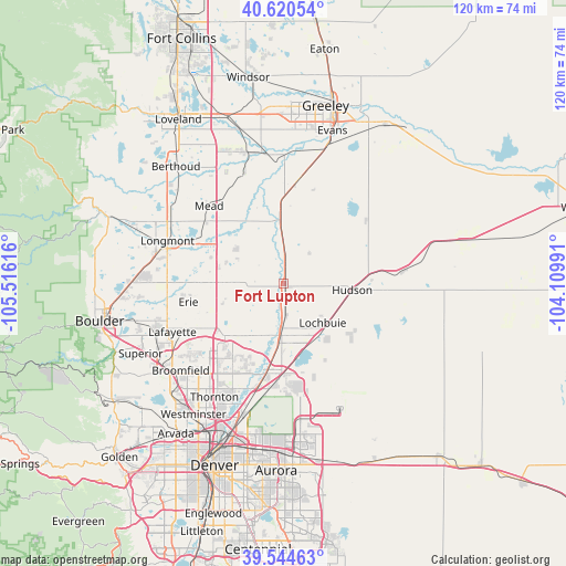
Fort Lupton GPS coordinates[2]
40° 5' 4.956" North, 104° 48' 46.908" West
| Map corner | latitude | longitude |
|---|---|---|
| Upper-left | 40.62054°, | -105.51616° |
| Center: | 40.08471°, | -104.81303° |
| Lower-right: | 39.54463°, | -104.10991° |
| Map W x H: | 119.6×119.6 km | = 74.3×74.3mi |
| max Lat: | 71.29058° ⇑45.6% North |
| Fort Lupton: | 40.08471° |
| min Lat: | ⇓54.4% South 19.06759° |
| min Long | Fort Lupton | max Long |
| -171.73463° | -104.81303° | -66.98998° |
| W 17%⇐ | ⇒83% E |
Elevation
Elevation of Fort Lupton is 1499 m = 4918 ft, and this is 1204.2 m = 3951 ft above average elevation for this country.
| Max E: |
3189 m = 10463 ft | 3.3% |
| Fort Lupton | 1499 m 4918 ft | |
| Avg. | 294.8 m = 967 ft | |
Min E: |
-60 m = -197 ft | 96.7% |
See also: United States elevation on elevation.city.
Geographical zone
Fort Lupton is located in North temperate zone (between Tropic of Cancer and the Arctic Circle). Distance of this Northern Tropic circle is 1851.1 km =1150.2 mi to South.| Distance of | km | miles | from Fort Lupton |
|---|---|---|---|
| North Pole | 5550.1 | 3448.7 | to North |
| Arctic Circle | 2944.2 | 1829.4 | to North |
| Tropic Cancer | 1851.1 | 1150.2 | to South |
| Equator | 4457 | 2769.5 | to South |


Nearby cities:
15 places around Fort Lupton: (largest is in red/bold)
• Aristocrat Ranchettes
5.1 km =3.2 mi,  57°
57°
• Brighton
11.1 km =6.9 mi,  183°
183°
• Dacono
10.8 km =6.7 mi,  270°
270°
• Erie
20.5 km =12.7 mi,  259°
259°
• Firestone
11 km =6.8 mi,  286°
286°
• Frederick
10.7 km =6.6 mi,  278°
278°
• Gilcrest
22.1 km =13.7 mi,  7°
7°
• Hudson
14.5 km =9 mi,  94°
94°
• Keenesburg
25.1 km =15.6 mi,  83°
83°
• Lafayette
25.6 km =15.9 mi,  246°
246°
• Lochbuie
11.9 km =7.4 mi,  136°
136°
• Longmont
26.2 km =16.3 mi, 290°
• Mead
22.8 km =14.2 mi,  316°
316°
• Platteville
14.5 km =9 mi,  356°
356°
• Todd Creek
12.9 km =8 mi,  203°
203°
Sources, notices
• [Note1] Compared only with cities in United States existing in our database
• [Src1] Map data: © OpenStreetMap contributors (CC-BY-SA)
• [Src2] Other city data from geonames.org with taken over terms of usage.
• [Src3] Geographical zone / Annual Mean Temperature by Robert A. Rohde @ Wikipedia
