Lafayette geodata
Lafayette (Colorado) is a populated place; located in United States in America/Denver (GMT-6) time zone. With population of 27,729 people, there are 1810 cities with bigger population in this country. Compared to other cities in United States, 53.5% of cities are located further ↓South; 83.4% of cities are located further →East and 97.3% of cities have lower elevation than Lafayette. Note1


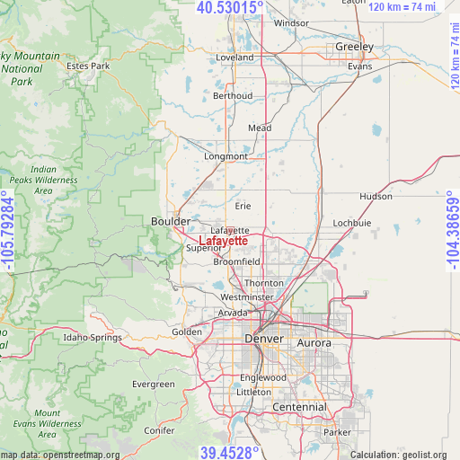
Lafayette GPS coordinates[2]
39° 59' 36.96" North, 105° 5' 22.956" West
| Map corner | latitude | longitude |
|---|---|---|
| Upper-left | 40.53015°, | -105.79284° |
| Center: | 39.9936°, | -105.08971° |
| Lower-right: | 39.4528°, | -104.38659° |
| Map W x H: | 119.8×119.8 km | = 74.4×74.4mi |
| max Lat: | 71.29058° ⇑46.5% North |
| Lafayette: | 39.9936° |
| min Lat: | ⇓53.5% South 19.06759° |
| min Long | Lafayette | max Long |
| -171.73463° | -105.08971° | -66.98998° |
| W 16.6%⇐ | ⇒83.4% E |
Elevation
Elevation of Lafayette is 1593 m = 5226 ft, and this is 1298.2 m = 4259 ft above average elevation for this country.
| Max E: |
3189 m = 10463 ft | 2.7% |
| Lafayette | 1593 m 5226 ft | |
| Avg. | 294.8 m = 967 ft | |
Min E: |
-60 m = -197 ft | 97.3% |
See also: United States elevation on elevation.city.
Geographical zone
Lafayette is located in North temperate zone (between Tropic of Cancer and the Arctic Circle). Distance of this Northern Tropic circle is 1841 km =1143.9 mi to South.| Distance of | km | miles | from Lafayette |
|---|---|---|---|
| North Pole | 5560.2 | 3454.9 | to North |
| Arctic Circle | 2954.3 | 1835.7 | to North |
| Tropic Cancer | 1841 | 1143.9 | to South |
| Equator | 4446.9 | 2763.2 | to South |


Nearby cities:
15 places around Lafayette: (largest is in red/bold)
• Boulder
15.6 km =9.7 mi,  278°
278°
• Broomfield
8.1 km =5 mi,  178°
178°
• Dacono
16.3 km =10.1 mi,  51°
51°
• Eldorado Springs
17.3 km =10.7 mi,  246°
246°
• Erie
7.2 km =4.5 mi,  28°
28°
• Federal Heights
17.6 km =10.9 mi,  153°
153°
• Frederick
17.5 km =10.9 mi, 47°
• Gunbarrel
10.4 km =6.5 mi,  318°
318°
• Louisville
4 km =2.5 mi,  243°
243°
• Niwot
14.1 km =8.8 mi,  330°
330°
• Northglenn
14.9 km =9.3 mi,  143°
143°
• Paragon Estates
7.4 km =4.6 mi,  259°
259°
• Shaw Heights
16.2 km =10.1 mi,  165°
165°
• Superior
8.1 km =5 mi, 235°
• Thornton
17.2 km =10.7 mi, 144°
Sources, notices
• [Note1] Compared only with cities in United States existing in our database
• [Src1] Map data: © OpenStreetMap contributors (CC-BY-SA)
• [Src2] Other city data from geonames.org with taken over terms of usage.
• [Src3] Geographical zone / Annual Mean Temperature by Robert A. Rohde @ Wikipedia
