Longmont geodata
Longmont (Colorado) is a populated place; located in United States in America/Denver (GMT-6) time zone. With population of 92,088 people, there are 401 cities with bigger population in this country. Compared to other cities in United States, 55.2% of cities are located further ↓South; 83.4% of cities are located further →East and 96.8% of cities have lower elevation than Longmont. Note1


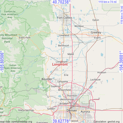
Longmont GPS coordinates[2]
40° 10' 1.956" North, 105° 6' 6.948" West
| Map corner | latitude | longitude |
|---|---|---|
| Upper-left | 40.70238°, | -105.80506° |
| Center: | 40.16721°, | -105.10193° |
| Lower-right: | 39.62778°, | -104.39881° |
| Map W x H: | 119.5×119.5 km | = 74.3×74.3mi |
| max Lat: | 71.29058° ⇑44.8% North |
| Longmont: | 40.16721° |
| min Lat: | ⇓55.2% South 19.06759° |
| min Long | Longmont | max Long |
| -171.73463° | -105.10193° | -66.98998° |
| W 16.6%⇐ | ⇒83.4% E |
Elevation
Elevation of Longmont is 1520 m = 4987 ft, and this is 1225.2 m = 4020 ft above average elevation for this country.
| Max E: |
3189 m = 10463 ft | 3.2% |
| Longmont | 1520 m 4987 ft | |
| Avg. | 294.8 m = 967 ft | |
Min E: |
-60 m = -197 ft | 96.8% |
See also: Longmont elevation on elevation.city.
Geographical zone
Longmont is located in North temperate zone (between Tropic of Cancer and the Arctic Circle). Distance of this Northern Tropic circle is 1860.3 km =1155.9 mi to South.| Distance of | km | miles | from Longmont |
|---|---|---|---|
| North Pole | 5540.9 | 3443 | to North |
| Arctic Circle | 2935 | 1823.7 | to North |
| Tropic Cancer | 1860.3 | 1155.9 | to South |
| Equator | 4466.2 | 2775.2 | to South |


Nearby cities:
15 places around Longmont: (largest is in red/bold)
• Altona
15.8 km =9.8 mi,  256°
256°
• Berthoud
15.8 km =9.8 mi,  6°
6°
• Campion
20.4 km =12.7 mi, 5°
• Dacono
16.6 km =10.3 mi,  123°
123°
• Erie
13.7 km =8.5 mi,  161°
161°
• Firestone
15.3 km =9.5 mi,  113°
113°
• Frederick
15.9 km =9.9 mi, 118°
• Gunbarrel
13 km =8.1 mi,  206°
206°
• Lafayette
19.3 km =12 mi,  176°
176°
• Lazy Acres
21.3 km =13.2 mi,  247°
247°
• Louisville
21.2 km =13.2 mi,  186°
186°
• Lyons
15.7 km =9.8 mi,  293°
293°
• Mead
11.4 km =7.1 mi,  50°
50°
• Niwot
9.2 km =5.7 mi,  219°
219°
• Paragon Estates
21.5 km =13.4 mi,  196°
196°
Sources, notices
• [Note1] Compared only with cities in United States existing in our database
• [Src1] Map data: © OpenStreetMap contributors (CC-BY-SA)
• [Src2] Other city data from geonames.org with taken over terms of usage.
• [Src3] Geographical zone / Annual Mean Temperature by Robert A. Rohde @ Wikipedia
