Berthoud geodata
Berthoud (Colorado) is a populated place; located in United States in America/Denver (GMT-6) time zone. With population of 6,031 people, there are 6383 cities with bigger population in this country. Compared to other cities in United States, 56.7% of cities are located further ↓South; 83.4% of cities are located further →East and 97% of cities have lower elevation than Berthoud. Note1


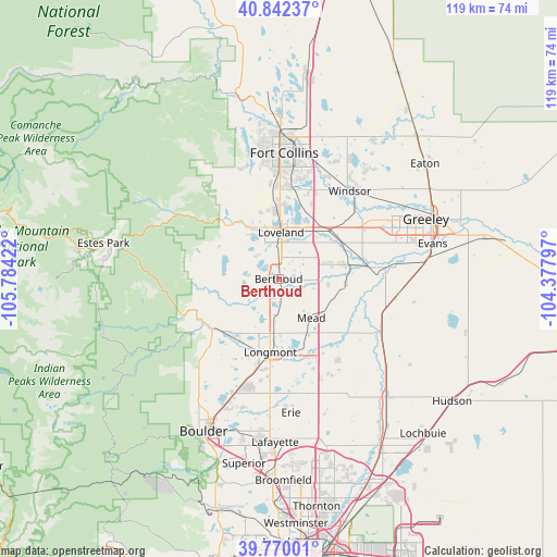
Berthoud GPS coordinates[2]
40° 18' 29.952" North, 105° 4' 51.924" West
| Map corner | latitude | longitude |
|---|---|---|
| Upper-left | 40.84237°, | -105.78422° |
| Center: | 40.30832°, | -105.08109° |
| Lower-right: | 39.77001°, | -104.37797° |
| Map W x H: | 119.2×119.2 km | = 74.1×74.1mi |
| max Lat: | 71.29058° ⇑43.3% North |
| Berthoud: | 40.30832° |
| min Lat: | ⇓56.7% South 19.06759° |
| min Long | Berthoud | max Long |
| -171.73463° | -105.08109° | -66.98998° |
| W 16.6%⇐ | ⇒83.4% E |
Elevation
Elevation of Berthoud is 1540 m = 5052 ft, and this is 1245.2 m = 4085 ft above average elevation for this country.
| Max E: |
3189 m = 10463 ft | 3% |
| Berthoud | 1540 m 5052 ft | |
| Avg. | 294.8 m = 967 ft | |
Min E: |
-60 m = -197 ft | 97% |
See also: United States elevation on elevation.city.
Geographical zone
Berthoud is located in North temperate zone (between Tropic of Cancer and the Arctic Circle). Distance of this Northern Tropic circle is 1875.9 km =1165.6 mi to South.| Distance of | km | miles | from Berthoud |
|---|---|---|---|
| North Pole | 5525.2 | 3433.2 | to North |
| Arctic Circle | 2919.3 | 1814 | to North |
| Tropic Cancer | 1875.9 | 1165.6 | to South |
| Equator | 4481.9 | 2784.9 | to South |


Nearby cities:
15 places around Berthoud: (largest is in red/bold)
• Altona
25.9 km =16.1 mi,  221°
221°
• Campion
4.6 km =2.9 mi,  3°
3°
• Firestone
25 km =15.5 mi,  150°
150°
• Frederick
26.3 km =16.3 mi, 152°
• Gilcrest
25.9 km =16.1 mi,  96°
96°
• Johnstown
14.7 km =9.1 mi,  77°
77°
• Longmont
15.8 km =9.8 mi,  186°
186°
• Loveland
10 km =6.2 mi, 2°
• Lyons
18.6 km =11.6 mi,  240°
240°
• Mead
10.9 km =6.8 mi,  139°
139°
• Milliken
19.3 km =12 mi, 83°
• Niwot
24 km =14.9 mi,  198°
198°
• Platteville
24.3 km =15.1 mi,  115°
115°
• Timnath
25.9 km =16.1 mi,  18°
18°
• Windsor
24.2 km =15 mi,  38°
38°
Sources, notices
• [Note1] Compared only with cities in United States existing in our database
• [Src1] Map data: © OpenStreetMap contributors (CC-BY-SA)
• [Src2] Other city data from geonames.org with taken over terms of usage.
• [Src3] Geographical zone / Annual Mean Temperature by Robert A. Rohde @ Wikipedia
