Downey geodata
Downey (Idaho) is a populated place; located in United States in America/Boise (GMT-6) time zone. With population of 616 people, there are 19520 cities with bigger population in this country. Compared to other cities in United States, 79.1% of cities are located further ↓South; 87.7% of cities are located further →East and 96.6% of cities have lower elevation than Downey. Note1


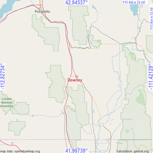
Downey GPS coordinates[2]
42° 25' 42.708" North, 112° 7' 27.876" West
| Map corner | latitude | longitude |
|---|---|---|
| Upper-left | 42.94537°, | -112.82754° |
| Center: | 42.42853°, | -112.12441° |
| Lower-right: | 41.90739°, | -111.42129° |
| Map W x H: | 115.4×115.4 km | = 71.7×71.7mi |
| max Lat: | 71.29058° ⇑20.9% North |
| Downey: | 42.42853° |
| min Lat: | ⇓79.1% South 19.06759° |
| min Long | Downey | max Long |
| -171.73463° | -112.12441° | -66.98998° |
| W 12.3%⇐ | ⇒87.7% E |
Elevation
Elevation of Downey is 1483 m = 4865 ft, and this is 1188.2 m = 3898 ft above average elevation for this country.
| Max E: |
3189 m = 10463 ft | 3.4% |
| Downey | 1483 m 4865 ft | |
| Avg. | 294.8 m = 967 ft | |
Min E: |
-60 m = -197 ft | 96.6% |
See also: United States elevation on elevation.city.
Geographical zone
Downey is located in North temperate zone (between Tropic of Cancer and the Arctic Circle). Distance of this Northern Tropic circle is 2111.7 km =1312.1 mi to South.| Distance of | km | miles | from Downey |
|---|---|---|---|
| North Pole | 5289.5 | 3286.7 | to North |
| Arctic Circle | 2683.6 | 1667.5 | to North |
| Tropic Cancer | 2111.7 | 1312.1 | to South |
| Equator | 4717.6 | 2931.4 | to South |


Nearby cities:
15 places around Downey: (largest is in red/bold)
• Arbon Valley
63.6 km =39.5 mi,  322°
322°
• Chubbuck
61.4 km =38.2 mi,  332°
332°
• Clarkston
56.9 km =35.4 mi,  173°
173°
• Franklin
53 km =32.9 mi,  150°
150°
• Grace
36.2 km =22.5 mi,  63°
63°
• Inkom
42.2 km =26.2 mi,  345°
345°
• Lewiston
55 km =34.2 mi,  156°
156°
• Malad City
28.3 km =17.6 mi,  201°
201°
• McCammon
25.3 km =15.7 mi, 347°
• Paris
63.5 km =39.5 mi,  110°
110°
• Pocatello
55.8 km =34.7 mi, 331°
• Preston
42.2 km =26.2 mi, 151°
• Richmond
61.8 km =38.4 mi, 155°
• Soda Springs
49.4 km =30.7 mi, 59°
• Trenton
58.7 km =36.5 mi, 165°
Sources, notices
• [Note1] Compared only with cities in United States existing in our database
• [Src1] Map data: © OpenStreetMap contributors (CC-BY-SA)
• [Src2] Other city data from geonames.org with taken over terms of usage.
• [Src3] Geographical zone / Annual Mean Temperature by Robert A. Rohde @ Wikipedia
