Pocatello geodata
Pocatello (Idaho) is a seat of a second-order administrative division; located in United States in America/Boise (GMT-6) time zone. With population of 54,441 people, there are 850 cities with bigger population in this country. Compared to other cities in United States, 82.3% of cities are located further ↓South; 88% of cities are located further →East and 95.7% of cities have lower elevation than Pocatello. Note1


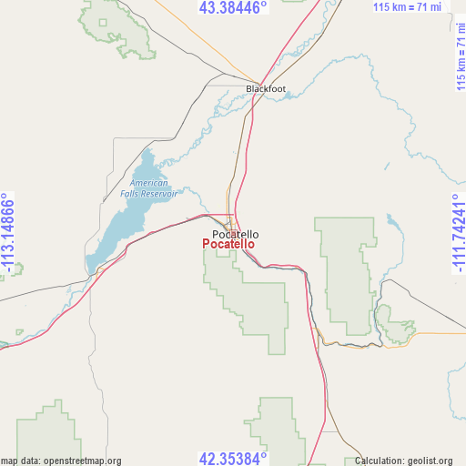
Pocatello GPS coordinates[2]
42° 52' 16.68" North, 112° 26' 43.908" West
| Map corner | latitude | longitude |
|---|---|---|
| Upper-left | 43.38446°, | -113.14866° |
| Center: | 42.8713°, | -112.44553° |
| Lower-right: | 42.35384°, | -111.74241° |
| Map W x H: | 114.6×114.6 km | = 71.2×71.2mi |
| max Lat: | 71.29058° ⇑17.7% North |
| Pocatello: | 42.8713° |
| min Lat: | ⇓82.3% South 19.06759° |
| min Long | Pocatello | max Long |
| -171.73463° | -112.44553° | -66.98998° |
| W 12%⇐ | ⇒88% E |
Elevation
Elevation of Pocatello is 1363 m = 4472 ft, and this is 1068.2 m = 3505 ft above average elevation for this country.
| Max E: |
3189 m = 10463 ft | 4.3% |
| Pocatello | 1363 m 4472 ft | |
| Avg. | 294.8 m = 967 ft | |
Min E: |
-60 m = -197 ft | 95.7% |
See also: Pocatello elevation on elevation.city.
Geographical zone
Pocatello is located in North temperate zone (between Tropic of Cancer and the Arctic Circle). Distance of this Northern Tropic circle is 2160.9 km =1342.7 mi to South.| Distance of | km | miles | from Pocatello |
|---|---|---|---|
| North Pole | 5240.2 | 3256.1 | to North |
| Arctic Circle | 2634.3 | 1636.9 | to North |
| Tropic Cancer | 2160.9 | 1342.7 | to South |
| Equator | 4766.8 | 2962 | to South |


Nearby cities:
15 places around Pocatello: (largest is in red/bold)
• Aberdeen
33 km =20.5 mi,  284°
284°
• American Falls
34.7 km =21.6 mi,  254°
254°
• Arbon Valley
12.2 km =7.6 mi, 277°
• Blackfoot
36.4 km =22.6 mi,  12°
12°
• Chubbuck
5.7 km =3.5 mi,  343°
343°
• Downey
55.8 km =34.7 mi,  151°
151°
• Fort Hall
18 km =11.2 mi,  1°
1°
• Grace
67 km =41.6 mi,  119°
119°
• Groveland
39.2 km =24.4 mi, 8°
• Inkom
17.7 km =11 mi, 118°
• McCammon
32.1 km =19.9 mi,  139°
139°
• Moreland
39.1 km =24.3 mi, 0°
• Riverside
36.2 km =22.5 mi, 1°
• Shelley
62.4 km =38.8 mi,  24°
24°
• Tyhee
9.1 km =5.7 mi,  349°
349°
Sources, notices
• [Note1] Compared only with cities in United States existing in our database
• [Src1] Map data: © OpenStreetMap contributors (CC-BY-SA)
• [Src2] Other city data from geonames.org with taken over terms of usage.
• [Src3] Geographical zone / Annual Mean Temperature by Robert A. Rohde @ Wikipedia
