Homedale geodata
Homedale (Idaho) is a populated place; located in United States in America/Boise (GMT-6) time zone. With population of 2,565 people, there are 10469 cities with bigger population in this country. Compared to other cities in United States, 86.8% of cities are located further ↓South; 89.6% of cities are located further →East and 90.7% of cities have lower elevation than Homedale. Note1


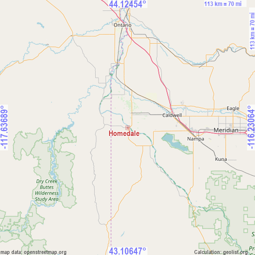
Homedale GPS coordinates[2]
43° 37' 3.576" North, 116° 56' 1.536" West
| Map corner | latitude | longitude |
|---|---|---|
| Upper-left | 44.12454°, | -117.63689° |
| Center: | 43.61766°, | -116.93376° |
| Lower-right: | 43.10647°, | -116.23064° |
| Map W x H: | 113.2×113.2 km | = 70.3×70.3mi |
| max Lat: | 71.29058° ⇑13.2% North |
| Homedale: | 43.61766° |
| min Lat: | ⇓86.8% South 19.06759° |
| min Long | Homedale | max Long |
| -171.73463° | -116.93376° | -66.98998° |
| W 10.4%⇐ | ⇒89.6% E |
Elevation
Elevation of Homedale is 681 m = 2234 ft, and this is 386.2 m = 1267 ft above average elevation for this country.
| Max E: |
3189 m = 10463 ft | 9.3% |
| Homedale | 681 m 2234 ft | |
| Avg. | 294.8 m = 967 ft | |
Min E: |
-60 m = -197 ft | 90.7% |
See also: United States elevation on elevation.city.
Geographical zone
Homedale is located in North temperate zone (between Tropic of Cancer and the Arctic Circle). Distance of this Northern Tropic circle is 2243.9 km =1394.3 mi to South.| Distance of | km | miles | from Homedale |
|---|---|---|---|
| North Pole | 5157.2 | 3204.5 | to North |
| Arctic Circle | 2551.3 | 1585.3 | to North |
| Tropic Cancer | 2243.9 | 1394.3 | to South |
| Equator | 4849.8 | 3013.5 | to South |


Nearby cities:
15 places around Homedale: (largest is in red/bold)
• Caldwell
20.5 km =12.7 mi,  75°
75°
• Fruitland
43.4 km =27 mi,  1°
1°
• Greenleaf
11.2 km =7 mi,  57°
57°
• Kuna
43.7 km =27.2 mi,  108°
108°
• Marsing
12.6 km =7.8 mi,  129°
129°
• Melba
42.3 km =26.3 mi, 129°
• Meridian
43.7 km =27.2 mi,  90°
90°
• Middleton
27.1 km =16.8 mi,  68°
68°
• Nampa
31 km =19.3 mi, 106°
• New Plymouth
40.2 km =25 mi,  13°
13°
• Notus
16 km =9.9 mi,  41°
41°
• Nyssa
29.2 km =18.1 mi,  350°
350°
• Parma
18.6 km =11.6 mi,  357°
357°
• Star
36.4 km =22.6 mi, 76°
• Wilder
6.8 km =4.2 mi,  15°
15°
Sources, notices
• [Note1] Compared only with cities in United States existing in our database
• [Src1] Map data: © OpenStreetMap contributors (CC-BY-SA)
• [Src2] Other city data from geonames.org with taken over terms of usage.
• [Src3] Geographical zone / Annual Mean Temperature by Robert A. Rohde @ Wikipedia
