Caldwell geodata
Caldwell (Idaho) is a seat of a second-order administrative division; located in United States in America/Boise (GMT-6) time zone. With population of 51,686 people, there are 915 cities with bigger population in this country. Compared to other cities in United States, 87.1% of cities are located further ↓South; 89.5% of cities are located further →East and 91.2% of cities have lower elevation than Caldwell. Note1


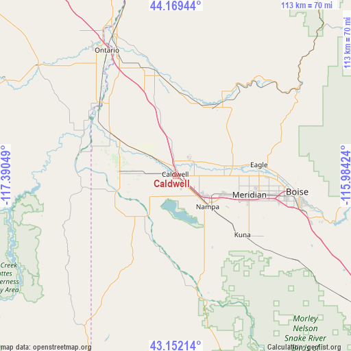
Caldwell GPS coordinates[2]
43° 39' 46.584" North, 116° 41' 14.496" West
| Map corner | latitude | longitude |
|---|---|---|
| Upper-left | 44.16944°, | -117.39049° |
| Center: | 43.66294°, | -116.68736° |
| Lower-right: | 43.15214°, | -115.98424° |
| Map W x H: | 113.1×113.1 km | = 70.3×70.3mi |
| max Lat: | 71.29058° ⇑12.9% North |
| Caldwell: | 43.66294° |
| min Lat: | ⇓87.1% South 19.06759° |
| min Long | Caldwell | max Long |
| -171.73463° | -116.68736° | -66.98998° |
| W 10.5%⇐ | ⇒89.5% E |
Elevation
Elevation of Caldwell is 723 m = 2372 ft, and this is 428.2 m = 1405 ft above average elevation for this country.
| Max E: |
3189 m = 10463 ft | 8.8% |
| Caldwell | 723 m 2372 ft | |
| Avg. | 294.8 m = 967 ft | |
Min E: |
-60 m = -197 ft | 91.2% |
See also: Caldwell elevation on elevation.city.
Geographical zone
Caldwell is located in North temperate zone (between Tropic of Cancer and the Arctic Circle). Distance of this Northern Tropic circle is 2248.9 km =1397.4 mi to South.| Distance of | km | miles | from Caldwell |
|---|---|---|---|
| North Pole | 5152.2 | 3201.4 | to North |
| Arctic Circle | 2546.3 | 1582.2 | to North |
| Tropic Cancer | 2248.9 | 1397.4 | to South |
| Equator | 4854.9 | 3016.7 | to South |


Nearby cities:
15 places around Caldwell: (largest is in red/bold)
• Eagle
27 km =16.8 mi,  82°
82°
• Emmett
27.9 km =17.3 mi,  32°
32°
• Greenleaf
10.4 km =6.5 mi,  275°
275°
• Homedale
20.5 km =12.7 mi,  255°
255°
• Kuna
28.7 km =17.8 mi,  131°
131°
• Marsing
16.5 km =10.3 mi,  217°
217°
• Melba
34.4 km =21.4 mi,  158°
158°
• Meridian
24.5 km =15.2 mi,  103°
103°
• Middleton
7.3 km =4.5 mi,  47°
47°
• Nampa
16.9 km =10.5 mi,  143°
143°
• Notus
11.5 km =7.1 mi,  307°
307°
• Nyssa
34.3 km =21.3 mi, 313°
• Parma
24.6 km =15.3 mi,  303°
303°
• Star
15.9 km =9.9 mi, 78°
• Wilder
18.1 km =11.2 mi,  274°
274°
Sources, notices
• [Note1] Compared only with cities in United States existing in our database
• [Src1] Map data: © OpenStreetMap contributors (CC-BY-SA)
• [Src2] Other city data from geonames.org with taken over terms of usage.
• [Src3] Geographical zone / Annual Mean Temperature by Robert A. Rohde @ Wikipedia
