Nampa geodata
Nampa (Idaho) is a populated place; located in United States in America/Boise (GMT-6) time zone. With population of 89,839 people, there are 410 cities with bigger population in this country. Compared to other cities in United States, 86.5% of cities are located further ↓South; 89.4% of cities are located further →East and 91.7% of cities have lower elevation than Nampa. Note1


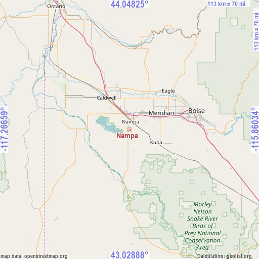
Nampa GPS coordinates[2]
43° 32' 26.592" North, 116° 33' 48.456" West
| Map corner | latitude | longitude |
|---|---|---|
| Upper-left | 44.04825°, | -117.26659° |
| Center: | 43.54072°, | -116.56346° |
| Lower-right: | 43.02888°, | -115.86034° |
| Map W x H: | 113.3×113.3 km | = 70.4×70.4mi |
| max Lat: | 71.29058° ⇑13.5% North |
| Nampa: | 43.54072° |
| min Lat: | ⇓86.5% South 19.06759° |
| min Long | Nampa | max Long |
| -171.73463° | -116.56346° | -66.98998° |
| W 10.6%⇐ | ⇒89.4% E |
Elevation
Elevation of Nampa is 767 m = 2516 ft, and this is 472.2 m = 1549 ft above average elevation for this country.
| Max E: |
3189 m = 10463 ft | 8.3% |
| Nampa | 767 m 2516 ft | |
| Avg. | 294.8 m = 967 ft | |
Min E: |
-60 m = -197 ft | 91.7% |
See also: Nampa elevation on elevation.city.
Geographical zone
Nampa is located in North temperate zone (between Tropic of Cancer and the Arctic Circle). Distance of this Northern Tropic circle is 2235.4 km =1389 mi to South.| Distance of | km | miles | from Nampa |
|---|---|---|---|
| North Pole | 5165.8 | 3209.9 | to North |
| Arctic Circle | 2559.9 | 1590.6 | to North |
| Tropic Cancer | 2235.4 | 1389 | to South |
| Equator | 4841.3 | 3008.2 | to South |


Nearby cities:
15 places around Nampa: (largest is in red/bold)
• Boise
30.1 km =18.7 mi,  74°
74°
• Caldwell
16.9 km =10.5 mi,  323°
323°
• Eagle
24.1 km =15 mi,  44°
44°
• Garden City
27.7 km =17.2 mi, 70°
• Greenleaf
25 km =15.5 mi,  305°
305°
• Hidden Spring
32.2 km =20 mi,  51°
51°
• Homedale
31 km =19.3 mi,  286°
286°
• Kuna
12.8 km =8 mi,  115°
115°
• Marsing
20.1 km =12.5 mi,  271°
271°
• Melba
18.6 km =11.6 mi,  171°
171°
• Meridian
16 km =9.9 mi,  60°
60°
• Middleton
19 km =11.8 mi,  346°
346°
• Notus
28.1 km =17.5 mi, 317°
• Star
17.8 km =11.1 mi,  18°
18°
• Wilder
31.9 km =19.8 mi,  298°
298°
Sources, notices
• [Note1] Compared only with cities in United States existing in our database
• [Src1] Map data: © OpenStreetMap contributors (CC-BY-SA)
• [Src2] Other city data from geonames.org with taken over terms of usage.
• [Src3] Geographical zone / Annual Mean Temperature by Robert A. Rohde @ Wikipedia
