Belt geodata
Belt (Montana) is a populated place; located in United States in America/Denver (GMT-6) time zone. With population of 596 people, there are 19749 cities with bigger population in this country. Compared to other cities in United States, 97.4% of cities are located further ↓South; 86.2% of cities are located further →East and 93.9% of cities have lower elevation than Belt. Note1


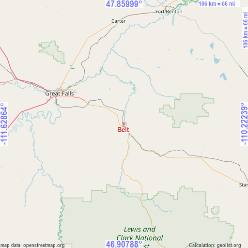
Belt GPS coordinates[2]
47° 23' 9.888" North, 110° 55' 31.836" West
| Map corner | latitude | longitude |
|---|---|---|
| Upper-left | 47.85999°, | -111.62864° |
| Center: | 47.38608°, | -110.92551° |
| Lower-right: | 46.90788°, | -110.22239° |
| Map W x H: | 105.9×105.9 km | = 65.8×65.8mi |
| max Lat: | 71.29058° ⇑2.6% North |
| Belt: | 47.38608° |
| min Lat: | ⇓97.4% South 19.06759° |
| min Long | Belt | max Long |
| -171.73463° | -110.92551° | -66.98998° |
| W 13.8%⇐ | ⇒86.2% E |
Elevation
Elevation of Belt is 1072 m = 3517 ft, and this is 777.2 m = 2550 ft above average elevation for this country.
| Max E: |
3189 m = 10463 ft | 6.1% |
| Belt | 1072 m 3517 ft | |
| Avg. | 294.8 m = 967 ft | |
Min E: |
-60 m = -197 ft | 93.9% |
See also: United States elevation on elevation.city.
Geographical zone
Belt is located in North temperate zone (between Tropic of Cancer and the Arctic Circle). Distance of this North polar circle is 2132.3 km =1324.9 mi to North.| Distance of | km | miles | from Belt |
|---|---|---|---|
| North Pole | 4738.2 | 2944.2 | to North |
| Arctic Circle | 2132.3 | 1324.9 | to North |
| Tropic Cancer | 2662.9 | 1654.6 | to South |
| Equator | 5268.8 | 3273.9 | to South |


Nearby cities:
15 places around Belt: (largest is in red/bold)
• Big Sandy
107 km =66.5 mi,  34°
34°
• Black Eagle
30.7 km =19.1 mi,  300°
300°
• Cascade
59.8 km =37.2 mi,  257°
257°
• Choteau
105.6 km =65.6 mi, 296°
• Fairfield
83.2 km =51.7 mi,  287°
287°
• Fort Benton
51.8 km =32.2 mi,  21°
21°
• Great Falls
30.9 km =19.2 mi, 294°
• Helena Valley Northeast
109 km =67.7 mi,  225°
225°
• Helena Valley Northwest
113 km =70.2 mi, 229°
• Malmstrom Air Force Base
23.5 km =14.6 mi, 304°
• Stanford
59.3 km =36.8 mi,  115°
115°
• Sun Prairie
45 km =28 mi, 291°
• Ulm
44 km =27.3 mi,  276°
276°
• Vaughn
50.5 km =31.4 mi, 292°
• White Sulphur Springs
93.2 km =57.9 mi,  178°
178°
Sources, notices
• [Note1] Compared only with cities in United States existing in our database
• [Src1] Map data: © OpenStreetMap contributors (CC-BY-SA)
• [Src2] Other city data from geonames.org with taken over terms of usage.
• [Src3] Geographical zone / Annual Mean Temperature by Robert A. Rohde @ Wikipedia
