Fort Benton geodata
Fort Benton (Montana) is a seat of a second-order administrative division; located in United States in America/Denver (GMT-6) time zone. With population of 1,460 people, there are 13839 cities with bigger population in this country. Compared to other cities in United States, 98.3% of cities are located further ↓South; 86% of cities are located further →East and 92% of cities have lower elevation than Fort Benton. Note1


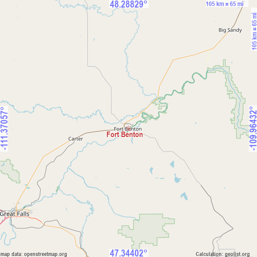
Fort Benton GPS coordinates[2]
47° 49' 5.88" North, 110° 40' 2.784" West
| Map corner | latitude | longitude |
|---|---|---|
| Upper-left | 48.28829°, | -111.37057° |
| Center: | 47.8183°, | -110.66744° |
| Lower-right: | 47.34402°, | -109.96432° |
| Map W x H: | 105×105 km | = 65.2×65.2mi |
| max Lat: | 71.29058° ⇑1.7% North |
| Fort Benton: | 47.8183° |
| min Lat: | ⇓98.3% South 19.06759° |
| min Long | Fort Benton | max Long |
| -171.73463° | -110.66744° | -66.98998° |
| W 14%⇐ | ⇒86% E |
Elevation
Elevation of Fort Benton is 803 m = 2635 ft, and this is 508.2 m = 1667 ft above average elevation for this country.
| Max E: |
3189 m = 10463 ft | 8% |
| Fort Benton | 803 m 2635 ft | |
| Avg. | 294.8 m = 967 ft | |
Min E: |
-60 m = -197 ft | 92% |
See also: United States elevation on elevation.city.
Geographical zone
Fort Benton is located in North temperate zone (between Tropic of Cancer and the Arctic Circle). Distance of this North polar circle is 2084.3 km =1295.1 mi to North.| Distance of | km | miles | from Fort Benton |
|---|---|---|---|
| North Pole | 4690.2 | 2914.4 | to North |
| Arctic Circle | 2084.3 | 1295.1 | to North |
| Tropic Cancer | 2711 | 1684.5 | to South |
| Equator | 5316.9 | 3303.8 | to South |


Nearby cities:
15 places around Fort Benton: (largest is in red/bold)
• Belt
51.8 km =32.2 mi,  201°
201°
• Big Sandy
57.5 km =35.7 mi,  45°
45°
• Black Eagle
56.2 km =34.9 mi,  234°
234°
• Cascade
98.6 km =61.3 mi, 231°
• Chester
80.1 km =49.8 mi,  343°
343°
• Conrad
102.9 km =63.9 mi,  292°
292°
• Fairfield
100.8 km =62.6 mi,  257°
257°
• Great Falls
59.2 km =36.8 mi, 233°
• Havre
109.2 km =67.9 mi,  41°
41°
• Havre North
111 km =69 mi, 41°
• Malmstrom Air Force Base
52 km =32.3 mi, 227°
• Stanford
81.3 km =50.5 mi,  155°
155°
• Sun Prairie
68.5 km =42.6 mi,  242°
242°
• Ulm
76.3 km =47.4 mi, 235°
• Vaughn
71.7 km =44.6 mi,  246°
246°
Sources, notices
• [Note1] Compared only with cities in United States existing in our database
• [Src1] Map data: © OpenStreetMap contributors (CC-BY-SA)
• [Src2] Other city data from geonames.org with taken over terms of usage.
• [Src3] Geographical zone / Annual Mean Temperature by Robert A. Rohde @ Wikipedia
