Townsend geodata
Townsend (Montana) is a seat of a second-order administrative division; located in United States in America/Denver (GMT-6) time zone. With population of 1,959 people, there are 12058 cities with bigger population in this country. Compared to other cities in United States, 95.5% of cities are located further ↓South; 86.6% of cities are located further →East and 94.4% of cities have lower elevation than Townsend. Note1


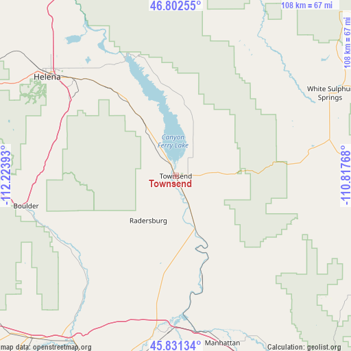
Townsend GPS coordinates[2]
46° 19' 8.76" North, 111° 31' 14.88" West
| Map corner | latitude | longitude |
|---|---|---|
| Upper-left | 46.80255°, | -112.22393° |
| Center: | 46.3191°, | -111.5208° |
| Lower-right: | 45.83134°, | -110.81768° |
| Map W x H: | 108×108 km | = 67.1×67.1mi |
| max Lat: | 71.29058° ⇑4.5% North |
| Townsend: | 46.3191° |
| min Lat: | ⇓95.5% South 19.06759° |
| min Long | Townsend | max Long |
| -171.73463° | -111.5208° | -66.98998° |
| W 13.4%⇐ | ⇒86.6% E |
Elevation
Elevation of Townsend is 1167 m = 3829 ft, and this is 872.2 m = 2862 ft above average elevation for this country.
| Max E: |
3189 m = 10463 ft | 5.6% |
| Townsend | 1167 m 3829 ft | |
| Avg. | 294.8 m = 967 ft | |
Min E: |
-60 m = -197 ft | 94.4% |
See also: United States elevation on elevation.city.
Geographical zone
Townsend is located in North temperate zone (between Tropic of Cancer and the Arctic Circle). Distance of this North polar circle is 2251 km =1398.7 mi to North.| Distance of | km | miles | from Townsend |
|---|---|---|---|
| North Pole | 4856.9 | 3017.9 | to North |
| Arctic Circle | 2251 | 1398.7 | to North |
| Tropic Cancer | 2544.3 | 1581 | to South |
| Equator | 5150.2 | 3200.2 | to South |


Nearby cities:
15 places around Townsend: (largest is in red/bold)
• Boulder
47 km =29.2 mi,  258°
258°
• Clancy
39.2 km =24.4 mi,  294°
294°
• East Helena
42.7 km =26.5 mi,  314°
314°
• Helena
49.8 km =30.9 mi, 307°
• Helena Valley Northeast
53.6 km =33.3 mi,  321°
321°
• Helena Valley Northwest
61.6 km =38.3 mi, 317°
• Helena Valley Southeast
45 km =28 mi, 317°
• Helena Valley West Central
56.3 km =35 mi, 312°
• Helena West Side
54.9 km =34.1 mi,  304°
304°
• Manhattan
53.4 km =33.2 mi,  164°
164°
• Montana City
39.8 km =24.7 mi, 307°
• South Hills
45.1 km =28 mi, 305°
• The Silos
9.2 km =5.7 mi,  327°
327°
• Three Forks
47.5 km =29.5 mi,  182°
182°
• White Sulphur Springs
53.8 km =33.4 mi,  61°
61°
Sources, notices
• [Note1] Compared only with cities in United States existing in our database
• [Src1] Map data: © OpenStreetMap contributors (CC-BY-SA)
• [Src2] Other city data from geonames.org with taken over terms of usage.
• [Src3] Geographical zone / Annual Mean Temperature by Robert A. Rohde @ Wikipedia
