Alliance geodata
Alliance (Nebraska) is a seat of a second-order administrative division; located in United States in America/Denver (GMT-6) time zone. With population of 8,522 people, there are 5010 cities with bigger population in this country. Compared to other cities in United States, 76.6% of cities are located further ↓South; 82.2% of cities are located further →East and 94.6% of cities have lower elevation than Alliance. Note1


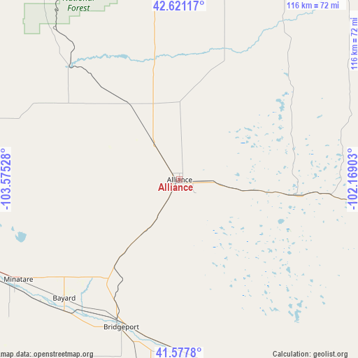
Alliance GPS coordinates[2]
42° 6' 5.868" North, 102° 52' 19.74" West
| Map corner | latitude | longitude |
|---|---|---|
| Upper-left | 42.62117°, | -103.57528° |
| Center: | 42.10163°, | -102.87215° |
| Lower-right: | 41.5778°, | -102.16903° |
| Map W x H: | 116×116 km | = 72.1×72.1mi |
| max Lat: | 71.29058° ⇑23.4% North |
| Alliance: | 42.10163° |
| min Lat: | ⇓76.6% South 19.06759° |
| min Long | Alliance | max Long |
| -171.73463° | -102.87215° | -66.98998° |
| W 17.8%⇐ | ⇒82.2% E |
Elevation
Elevation of Alliance is 1214 m = 3983 ft, and this is 919.2 m = 3016 ft above average elevation for this country.
| Max E: |
3189 m = 10463 ft | 5.4% |
| Alliance | 1214 m 3983 ft | |
| Avg. | 294.8 m = 967 ft | |
Min E: |
-60 m = -197 ft | 94.6% |
See also: United States elevation on elevation.city.
Geographical zone
Alliance is located in North temperate zone (between Tropic of Cancer and the Arctic Circle). Distance of this Northern Tropic circle is 2075.3 km =1289.5 mi to South.| Distance of | km | miles | from Alliance |
|---|---|---|---|
| North Pole | 5325.8 | 3309.3 | to North |
| Arctic Circle | 2719.9 | 1690.1 | to North |
| Tropic Cancer | 2075.3 | 1289.5 | to South |
| Equator | 4681.3 | 2908.8 | to South |


Nearby cities:
15 places around Alliance: (largest is in red/bold)
• Bayard
53.7 km =33.4 mi,  224°
224°
• Bridgeport
52 km =32.3 mi,  201°
201°
• Chadron
81.6 km =50.7 mi,  352°
352°
• Crawford
78.4 km =48.7 mi,  325°
325°
• Gering
72 km =44.7 mi,  244°
244°
• Hay Springs
66.4 km =41.3 mi,  13°
13°
• Hemingford
29.5 km =18.3 mi, 325°
• Hyannis
92.4 km =57.4 mi,  96°
96°
• Minatare
61.5 km =38.2 mi, 238°
• Mitchell
79.4 km =49.3 mi,  256°
256°
• Morrill
88.4 km =54.9 mi, 259°
• Oshkosh
89 km =55.3 mi,  150°
150°
• Rushville
76.3 km =47.4 mi,  26°
26°
• Scottsbluff
70.7 km =43.9 mi,  248°
248°
• Terrytown
71.1 km =44.2 mi, 246°
Sources, notices
• [Note1] Compared only with cities in United States existing in our database
• [Src1] Map data: © OpenStreetMap contributors (CC-BY-SA)
• [Src2] Other city data from geonames.org with taken over terms of usage.
• [Src3] Geographical zone / Annual Mean Temperature by Robert A. Rohde @ Wikipedia
