Terrytown geodata
Terrytown (Nebraska) is a populated place; located in United States in America/Denver (GMT-6) time zone. With population of 1,172 people, there are 15277 cities with bigger population in this country. Compared to other cities in United States, 74.3% of cities are located further ↓South; 82.5% of cities are located further →East and 94.5% of cities have lower elevation than Terrytown. Note1


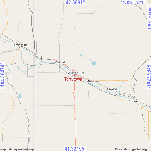
Terrytown GPS coordinates[2]
41° 50' 50.892" North, 103° 39' 41.796" West
| Map corner | latitude | longitude |
|---|---|---|
| Upper-left | 42.3691°, | -104.36474° |
| Center: | 41.84747°, | -103.66161° |
| Lower-right: | 41.32155°, | -102.95849° |
| Map W x H: | 116.5×116.5 km | = 72.4×72.4mi |
| max Lat: | 71.29058° ⇑25.7% North |
| Terrytown: | 41.84747° |
| min Lat: | ⇓74.3% South 19.06759° |
| min Long | Terrytown | max Long |
| -171.73463° | -103.66161° | -66.98998° |
| W 17.5%⇐ | ⇒82.5% E |
Elevation
Elevation of Terrytown is 1183 m = 3881 ft, and this is 888.2 m = 2914 ft above average elevation for this country.
| Max E: |
3189 m = 10463 ft | 5.5% |
| Terrytown | 1183 m 3881 ft | |
| Avg. | 294.8 m = 967 ft | |
Min E: |
-60 m = -197 ft | 94.5% |
See also: United States elevation on elevation.city.
Geographical zone
Terrytown is located in North temperate zone (between Tropic of Cancer and the Arctic Circle). Distance of this Northern Tropic circle is 2047.1 km =1272 mi to South.| Distance of | km | miles | from Terrytown |
|---|---|---|---|
| North Pole | 5354.1 | 3326.9 | to North |
| Arctic Circle | 2748.2 | 1707.7 | to North |
| Tropic Cancer | 2047.1 | 1272 | to South |
| Equator | 4653 | 2891.2 | to South |


Nearby cities:
15 places around Terrytown: (largest is in red/bold)
• Alliance
71.1 km =44.2 mi,  66°
66°
• Bayard
29.8 km =18.5 mi,  110°
110°
• Bridgeport
50.9 km =31.6 mi, 113°
• Crawford
95.1 km =59.1 mi,  12°
12°
• Gering
2.4 km =1.5 mi,  177°
177°
• Harrisburg
33 km =20.5 mi,  191°
191°
• Harrison
95.1 km =59.1 mi,  348°
348°
• Hemingford
71.7 km =44.6 mi,  42°
42°
• Kimball
68 km =42.3 mi, 180°
• Minatare
13.7 km =8.5 mi, 107°
• Mitchell
15.9 km =9.9 mi,  310°
310°
• Morrill
25.4 km =15.8 mi,  300°
300°
• Pine Bluffs
81.4 km =50.6 mi,  204°
204°
• Scottsbluff
2.2 km =1.4 mi, 347°
• Torrington
49.4 km =30.7 mi, 298°
Sources, notices
• [Note1] Compared only with cities in United States existing in our database
• [Src1] Map data: © OpenStreetMap contributors (CC-BY-SA)
• [Src2] Other city data from geonames.org with taken over terms of usage.
• [Src3] Geographical zone / Annual Mean Temperature by Robert A. Rohde @ Wikipedia
