Beavercreek geodata
Beavercreek (Oregon) is a populated place; located in United States in America/Los_Angeles (GMT-7) time zone. With population of 4,485 people, there are 7660 cities with bigger population in this country. Compared to other cities in United States, 93.4% of cities are located further ↓South; 96.7% of cities are located further →East and 58.8% of cities have higher elevation than Beavercreek. Note1


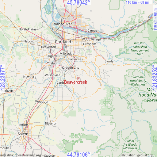
Beavercreek GPS coordinates[2]
45° 17' 16.44" North, 122° 32' 8.304" West
| Map corner | latitude | longitude |
|---|---|---|
| Upper-left | 45.78042°, | -123.23877° |
| Center: | 45.2879°, | -122.53564° |
| Lower-right: | 44.79106°, | -121.83252° |
| Map W x H: | 110×110 km | = 68.4×68.4mi |
| max Lat: | 71.29058° ⇑6.6% North |
| Beavercreek: | 45.2879° |
| min Lat: | ⇓93.4% South 19.06759° |
| min Long | Beavercreek | max Long |
| -171.73463° | -122.53564° | -66.98998° |
| W 3.3%⇐ | ⇒96.7% E |
Elevation
Elevation of Beavercreek is 161 m = 528 ft, and this is 133.8 m = 439 ft below average elevation for this country.
| Max E: |
3189 m = 10463 ft | 58.8% |
| Avg. | 294.8 m = 967 ft | |
| Beavercreek | 161 m = 528 ft | |
Min E: |
-60 m = -197 ft | 41.2% |
See also: United States elevation on elevation.city.
Geographical zone
Beavercreek is located in North temperate zone (between Tropic of Cancer and the Arctic Circle). Distance of this North polar circle is 2365.6 km =1469.9 mi to North.| Distance of | km | miles | from Beavercreek |
|---|---|---|---|
| North Pole | 4971.5 | 3089.1 | to North |
| Arctic Circle | 2365.6 | 1469.9 | to North |
| Tropic Cancer | 2429.6 | 1509.7 | to South |
| Equator | 5035.5 | 3128.9 | to South |


Nearby cities:
15 places around Beavercreek: (largest is in red/bold)
• Canby
12.6 km =7.8 mi,  257°
257°
• Clackamas
13.6 km =8.5 mi,  348°
348°
• Damascus
15.6 km =9.7 mi,  22°
22°
• Estacada
15.8 km =9.8 mi,  89°
89°
• Gladstone
11.3 km =7 mi,  335°
335°
• Happy Valley
17.7 km =11 mi,  1°
1°
• Jennings Lodge
13 km =8.1 mi,  332°
332°
• Johnson City
13.4 km =8.3 mi, 345°
• Molalla
16 km =9.9 mi,  191°
191°
• Mulino
8.2 km =5.1 mi,  206°
206°
• Oak Grove
16.5 km =10.3 mi, 330°
• Oatfield
14.9 km =9.3 mi, 340°
• Oregon City
9.5 km =5.9 mi,  324°
324°
• Stafford
16.5 km =10.3 mi,  297°
297°
• West Linn
10.5 km =6.5 mi, 325°
Sources, notices
• [Note1] Compared only with cities in United States existing in our database
• [Src1] Map data: © OpenStreetMap contributors (CC-BY-SA)
• [Src2] Other city data from geonames.org with taken over terms of usage.
• [Src3] Geographical zone / Annual Mean Temperature by Robert A. Rohde @ Wikipedia
