Mulino geodata
Mulino (Oregon) is a populated place; located in United States in America/Los_Angeles (GMT-7) time zone. With population of 2,103 people, there are 11607 cities with bigger population in this country. Compared to other cities in United States, 93.3% of cities are located further ↓South; 96.9% of cities are located further →East and 74.4% of cities have higher elevation than Mulino. Note1


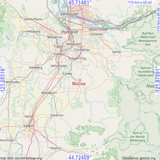
Mulino GPS coordinates[2]
45° 13' 17.436" North, 122° 34' 55.308" West
| Map corner | latitude | longitude |
|---|---|---|
| Upper-left | 45.71461°, | -123.28516° |
| Center: | 45.22151°, | -122.58203° |
| Lower-right: | 44.72409°, | -121.87891° |
| Map W x H: | 110.1×110.1 km | = 68.4×68.4mi |
| max Lat: | 71.29058° ⇑6.7% North |
| Mulino: | 45.22151° |
| min Lat: | ⇓93.3% South 19.06759° |
| min Long | Mulino | max Long |
| -171.73463° | -122.58203° | -66.98998° |
| W 3.1%⇐ | ⇒96.9% E |
Elevation
Elevation of Mulino is 75 m = 246 ft, and this is 219.8 m = 721 ft below average elevation for this country.
| Max E: |
3189 m = 10463 ft | 74.4% |
| Avg. | 294.8 m = 967 ft | |
| Mulino | 75 m = 246 ft | |
Min E: |
-60 m = -197 ft | 25.6% |
See also: United States elevation on elevation.city.
Geographical zone
Mulino is located in North temperate zone (between Tropic of Cancer and the Arctic Circle). Distance of this North polar circle is 2373 km =1474.5 mi to North.| Distance of | km | miles | from Mulino |
|---|---|---|---|
| North Pole | 4978.9 | 3093.7 | to North |
| Arctic Circle | 2373 | 1474.5 | to North |
| Tropic Cancer | 2422.2 | 1505.1 | to South |
| Equator | 5028.2 | 3124.4 | to South |


Nearby cities:
15 places around Mulino: (largest is in red/bold)
• Aurora
13.7 km =8.5 mi,  274°
274°
• Beavercreek
8.2 km =5.1 mi,  26°
26°
• Canby
9.8 km =6.1 mi,  297°
297°
• Clackamas
20.7 km =12.9 mi,  2°
2°
• Donald
20.1 km =12.5 mi, 270°
• Estacada
20.9 km =13 mi,  68°
68°
• Gladstone
17.7 km =11 mi,  356°
356°
• Hubbard
18.2 km =11.3 mi,  256°
256°
• Jennings Lodge
19 km =11.8 mi,  352°
352°
• Johnson City
20.4 km =12.7 mi, 0°
• Molalla
8.3 km =5.2 mi,  177°
177°
• Oregon City
15.2 km =9.4 mi, 352°
• Stafford
18.7 km =11.6 mi,  323°
323°
• West Linn
16.2 km =10.1 mi, 351°
• Wilsonville
17.3 km =10.7 mi, 300°
Sources, notices
• [Note1] Compared only with cities in United States existing in our database
• [Src1] Map data: © OpenStreetMap contributors (CC-BY-SA)
• [Src2] Other city data from geonames.org with taken over terms of usage.
• [Src3] Geographical zone / Annual Mean Temperature by Robert A. Rohde @ Wikipedia
