Molalla geodata
Molalla (Oregon) is a populated place; located in United States in America/Los_Angeles (GMT-7) time zone. With population of 8,972 people, there are 4815 cities with bigger population in this country. Compared to other cities in United States, 93.1% of cities are located further ↓South; 96.8% of cities are located further →East and 67.1% of cities have higher elevation than Molalla. Note1


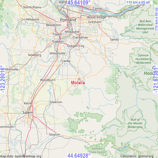
Molalla GPS coordinates[2]
45° 8' 50.424" North, 122° 34' 37.308" West
| Map corner | latitude | longitude |
|---|---|---|
| Upper-left | 45.64109°, | -123.28016° |
| Center: | 45.14734°, | -122.57703° |
| Lower-right: | 44.64928°, | -121.87391° |
| Map W x H: | 110.3×110.3 km | = 68.5×68.5mi |
| max Lat: | 71.29058° ⇑6.9% North |
| Molalla: | 45.14734° |
| min Lat: | ⇓93.1% South 19.06759° |
| min Long | Molalla | max Long |
| -171.73463° | -122.57703° | -66.98998° |
| W 3.2%⇐ | ⇒96.8% E |
Elevation
Elevation of Molalla is 117 m = 384 ft, and this is 177.8 m = 583 ft below average elevation for this country.
| Max E: |
3189 m = 10463 ft | 67.1% |
| Avg. | 294.8 m = 967 ft | |
| Molalla | 117 m = 384 ft | |
Min E: |
-60 m = -197 ft | 32.9% |
See also: United States elevation on elevation.city.
Geographical zone
Molalla is located in North temperate zone (between Tropic of Cancer and the Arctic Circle). Distance of this North polar circle is 2381.3 km =1479.7 mi to North.| Distance of | km | miles | from Molalla |
|---|---|---|---|
| North Pole | 4987.1 | 3098.8 | to North |
| Arctic Circle | 2381.3 | 1479.7 | to North |
| Tropic Cancer | 2414 | 1500 | to South |
| Equator | 5019.9 | 3119.2 | to South |


Nearby cities:
15 places around Molalla: (largest is in red/bold)
• Aurora
16.8 km =10.4 mi,  303°
303°
• Beavercreek
16 km =9.9 mi,  11°
11°
• Canby
15.7 km =9.8 mi,  324°
324°
• Donald
22.2 km =13.8 mi,  292°
292°
• Estacada
24.8 km =15.4 mi,  50°
50°
• Gervais
25.5 km =15.8 mi,  260°
260°
• Hubbard
18.5 km =11.5 mi,  282°
282°
• Mount Angel
19.6 km =12.2 mi,  243°
243°
• Mulino
8.3 km =5.2 mi,  357°
357°
• Oregon City
23.5 km =14.6 mi,  354°
354°
• Silverton
22.6 km =14 mi,  225°
225°
• Stafford
26 km =16.2 mi,  333°
333°
• West Linn
24.4 km =15.2 mi, 353°
• Wilsonville
22.9 km =14.2 mi, 317°
• Woodburn
21.8 km =13.5 mi,  268°
268°
Sources, notices
• [Note1] Compared only with cities in United States existing in our database
• [Src1] Map data: © OpenStreetMap contributors (CC-BY-SA)
• [Src2] Other city data from geonames.org with taken over terms of usage.
• [Src3] Geographical zone / Annual Mean Temperature by Robert A. Rohde @ Wikipedia
