Four Corners geodata
Four Corners (Oregon) is a populated place; located in United States in America/Los_Angeles (GMT-7) time zone. With population of 15,947 people, there are 3070 cities with bigger population in this country. Compared to other cities in United States, 92.2% of cities are located further ↓South; 97.8% of cities are located further →East and 75.5% of cities have higher elevation than Four Corners. Note1


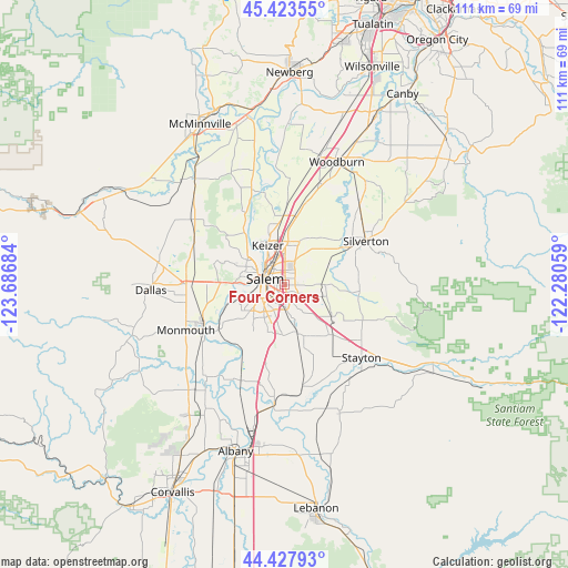
Four Corners GPS coordinates[2]
44° 55' 40.44" North, 122° 59' 1.356" West
| Map corner | latitude | longitude |
|---|---|---|
| Upper-left | 45.42355°, | -123.68684° |
| Center: | 44.9279°, | -122.98371° |
| Lower-right: | 44.42793°, | -122.28059° |
| Map W x H: | 110.7×110.7 km | = 68.8×68.8mi |
| max Lat: | 71.29058° ⇑7.8% North |
| Four Corners: | 44.9279° |
| min Lat: | ⇓92.2% South 19.06759° |
| min Long | Four Corners | max Long |
| -171.73463° | -122.98371° | -66.98998° |
| W 2.2%⇐ | ⇒97.8% E |
Elevation
Elevation of Four Corners is 69 m = 226 ft, and this is 225.8 m = 741 ft below average elevation for this country.
| Max E: |
3189 m = 10463 ft | 75.5% |
| Avg. | 294.8 m = 967 ft | |
| Four Corners | 69 m = 226 ft | |
Min E: |
-60 m = -197 ft | 24.5% |
See also: United States elevation on elevation.city.
Geographical zone
Four Corners is located in North temperate zone (between Tropic of Cancer and the Arctic Circle). Distance of this Northern Tropic circle is 2389.6 km =1484.8 mi to South.| Distance of | km | miles | from Four Corners |
|---|---|---|---|
| North Pole | 5011.5 | 3114 | to North |
| Arctic Circle | 2405.7 | 1494.8 | to North |
| Tropic Cancer | 2389.6 | 1484.8 | to South |
| Equator | 4995.5 | 3104.1 | to South |


Nearby cities:
15 places around Four Corners: (largest is in red/bold)
• Aumsville
13.1 km =8.1 mi,  137°
137°
• Dallas
26.3 km =16.3 mi,  267°
267°
• Gervais
21.2 km =13.2 mi,  18°
18°
• Hayesville
6.5 km =4 mi,  0°
0°
• Independence
18.1 km =11.2 mi,  241°
241°
• Jefferson
23.3 km =14.5 mi,  185°
185°
• Keizer
7.7 km =4.8 mi,  334°
334°
• Monmouth
21.6 km =13.4 mi,  245°
245°
• Mount Angel
21.2 km =13.2 mi,  42°
42°
• Salem
4.4 km =2.7 mi,  292°
292°
• Silverton
18 km =11.2 mi,  61°
61°
• Stayton
20.6 km =12.8 mi,  133°
133°
• Sublimity
18.5 km =11.5 mi, 126°
• Turner
9.7 km =6 mi,  165°
165°
• Woodburn
26 km =16.2 mi, 22°
Sources, notices
• [Note1] Compared only with cities in United States existing in our database
• [Src1] Map data: © OpenStreetMap contributors (CC-BY-SA)
• [Src2] Other city data from geonames.org with taken over terms of usage.
• [Src3] Geographical zone / Annual Mean Temperature by Robert A. Rohde @ Wikipedia
