Jefferson geodata
Jefferson (Oregon) is a populated place; located in United States in America/Los_Angeles (GMT-7) time zone. With population of 3,247 people, there are 9236 cities with bigger population in this country. Compared to other cities in United States, 91.3% of cities are located further ↓South; 97.9% of cities are located further →East and 75.5% of cities have higher elevation than Jefferson. Note1


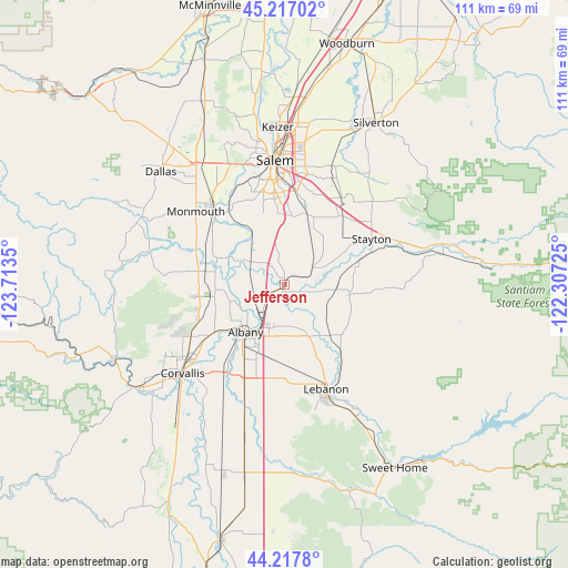
Jefferson GPS coordinates[2]
44° 43' 10.452" North, 123° 0' 37.332" West
| Map corner | latitude | longitude |
|---|---|---|
| Upper-left | 45.21702°, | -123.7135° |
| Center: | 44.71957°, | -123.01037° |
| Lower-right: | 44.2178°, | -122.30725° |
| Map W x H: | 111.1×111.1 km | = 69×69mi |
| max Lat: | 71.29058° ⇑8.7% North |
| Jefferson: | 44.71957° |
| min Lat: | ⇓91.3% South 19.06759° |
| min Long | Jefferson | max Long |
| -171.73463° | -123.01037° | -66.98998° |
| W 2.1%⇐ | ⇒97.9% E |
Elevation
Elevation of Jefferson is 69 m = 226 ft, and this is 225.8 m = 741 ft below average elevation for this country.
| Max E: |
3189 m = 10463 ft | 75.5% |
| Avg. | 294.8 m = 967 ft | |
| Jefferson | 69 m = 226 ft | |
Min E: |
-60 m = -197 ft | 24.5% |
See also: United States elevation on elevation.city.
Geographical zone
Jefferson is located in North temperate zone (between Tropic of Cancer and the Arctic Circle). Distance of this Northern Tropic circle is 2366.4 km =1470.4 mi to South.| Distance of | km | miles | from Jefferson |
|---|---|---|---|
| North Pole | 5034.7 | 3128.4 | to North |
| Arctic Circle | 2428.8 | 1509.2 | to North |
| Tropic Cancer | 2366.4 | 1470.4 | to South |
| Equator | 4972.4 | 3089.7 | to South |


Nearby cities:
15 places around Jefferson: (largest is in red/bold)
• Adair Village
17.3 km =10.7 mi,  251°
251°
• Albany
11.9 km =7.4 mi,  219°
219°
• Aumsville
17.4 km =10.8 mi,  39°
39°
• Four Corners
23.3 km =14.5 mi,  5°
5°
• Independence
20.2 km =12.6 mi,  316°
316°
• Lebanon
21.9 km =13.6 mi,  158°
158°
• Millersburg
5.9 km =3.7 mi, 223°
• Monmouth
22.7 km =14.1 mi,  309°
309°
• Salem
24.9 km =15.5 mi,  355°
355°
• Scio
12.8 km =8 mi,  97°
97°
• South Lebanon
25.2 km =15.7 mi, 160°
• Stayton
19.3 km =12 mi,  62°
62°
• Sublimity
21 km =13 mi,  54°
54°
• Tangent
21.3 km =13.2 mi,  201°
201°
• Turner
14.5 km =9 mi,  18°
18°
Sources, notices
• [Note1] Compared only with cities in United States existing in our database
• [Src1] Map data: © OpenStreetMap contributors (CC-BY-SA)
• [Src2] Other city data from geonames.org with taken over terms of usage.
• [Src3] Geographical zone / Annual Mean Temperature by Robert A. Rohde @ Wikipedia
