Lafayette geodata
Lafayette (Oregon) is a populated place; located in United States in America/Los_Angeles (GMT-7) time zone. With population of 3,969 people, there are 8255 cities with bigger population in this country. Compared to other cities in United States, 93.3% of cities are located further ↓South; 98% of cities are located further →East and 78.8% of cities have higher elevation than Lafayette. Note1


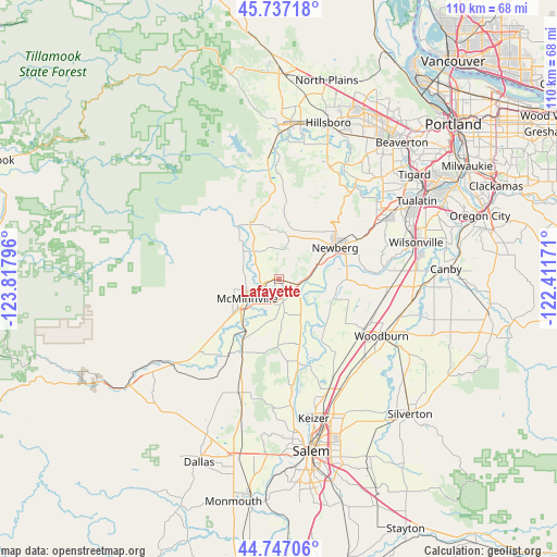
Lafayette GPS coordinates[2]
45° 14' 39.408" North, 123° 6' 53.388" West
| Map corner | latitude | longitude |
|---|---|---|
| Upper-left | 45.73718°, | -123.81796° |
| Center: | 45.24428°, | -123.11483° |
| Lower-right: | 44.74706°, | -122.41171° |
| Map W x H: | 110.1×110.1 km | = 68.4×68.4mi |
| max Lat: | 71.29058° ⇑6.7% North |
| Lafayette: | 45.24428° |
| min Lat: | ⇓93.3% South 19.06759° |
| min Long | Lafayette | max Long |
| -171.73463° | -123.11483° | -66.98998° |
| W 2%⇐ | ⇒98% E |
Elevation
Elevation of Lafayette is 52 m = 171 ft, and this is 242.8 m = 797 ft below average elevation for this country.
| Max E: |
3189 m = 10463 ft | 78.8% |
| Avg. | 294.8 m = 967 ft | |
| Lafayette | 52 m = 171 ft | |
Min E: |
-60 m = -197 ft | 21.2% |
See also: United States elevation on elevation.city.
Geographical zone
Lafayette is located in North temperate zone (between Tropic of Cancer and the Arctic Circle). Distance of this North polar circle is 2370.5 km =1473 mi to North.| Distance of | km | miles | from Lafayette |
|---|---|---|---|
| North Pole | 4976.4 | 3092.2 | to North |
| Arctic Circle | 2370.5 | 1473 | to North |
| Tropic Cancer | 2424.8 | 1506.7 | to South |
| Equator | 5030.7 | 3125.9 | to South |


Nearby cities:
15 places around Lafayette: (largest is in red/bold)
• Amity
16 km =9.9 mi,  206°
206°
• Carlton
7.4 km =4.6 mi,  319°
319°
• Dayton
4 km =2.5 mi,  130°
130°
• Donald
21.7 km =13.5 mi,  96°
96°
• Dundee
9 km =5.6 mi,  65°
65°
• Gaston
21.4 km =13.3 mi,  354°
354°
• Gervais
22.8 km =14.2 mi, 131°
• Hubbard
25 km =15.5 mi,  105°
105°
• McMinnville
7.6 km =4.7 mi,  239°
239°
• Newberg
12.7 km =7.9 mi,  60°
60°
• Sheridan
27.2 km =16.9 mi,  233°
233°
• Sherwood
24.8 km =15.4 mi, 59°
• Wilsonville
27.4 km =17 mi,  76°
76°
• Woodburn
23.2 km =14.4 mi,  118°
118°
• Yamhill
12.2 km =7.6 mi,  332°
332°
Sources, notices
• [Note1] Compared only with cities in United States existing in our database
• [Src1] Map data: © OpenStreetMap contributors (CC-BY-SA)
• [Src2] Other city data from geonames.org with taken over terms of usage.
• [Src3] Geographical zone / Annual Mean Temperature by Robert A. Rohde @ Wikipedia
