Sheridan geodata
Sheridan (Oregon) is a populated place; located in United States in America/Los_Angeles (GMT-7) time zone. With population of 6,094 people, there are 6339 cities with bigger population in this country. Compared to other cities in United States, 92.9% of cities are located further ↓South; 98.3% of cities are located further →East and 77.9% of cities have higher elevation than Sheridan. Note1


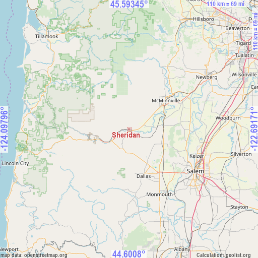
Sheridan GPS coordinates[2]
45° 5' 57.408" North, 123° 23' 41.388" West
| Map corner | latitude | longitude |
|---|---|---|
| Upper-left | 45.59345°, | -124.09796° |
| Center: | 45.09928°, | -123.39483° |
| Lower-right: | 44.6008°, | -122.69171° |
| Map W x H: | 110.4×110.4 km | = 68.6×68.6mi |
| max Lat: | 71.29058° ⇑7.1% North |
| Sheridan: | 45.09928° |
| min Lat: | ⇓92.9% South 19.06759° |
| min Long | Sheridan | max Long |
| -171.73463° | -123.39483° | -66.98998° |
| W 1.7%⇐ | ⇒98.3% E |
Elevation
Elevation of Sheridan is 56 m = 184 ft, and this is 238.8 m = 783 ft below average elevation for this country.
| Max E: |
3189 m = 10463 ft | 77.9% |
| Avg. | 294.8 m = 967 ft | |
| Sheridan | 56 m = 184 ft | |
Min E: |
-60 m = -197 ft | 22.1% |
See also: United States elevation on elevation.city.
Geographical zone
Sheridan is located in North temperate zone (between Tropic of Cancer and the Arctic Circle). Distance of this North polar circle is 2386.6 km =1483 mi to North.| Distance of | km | miles | from Sheridan |
|---|---|---|---|
| North Pole | 4992.5 | 3102.2 | to North |
| Arctic Circle | 2386.6 | 1483 | to North |
| Tropic Cancer | 2408.7 | 1496.7 | to South |
| Equator | 5014.6 | 3115.9 | to South |


Nearby cities:
15 places around Sheridan: (largest is in red/bold)
• Amity
14.8 km =9.2 mi,  82°
82°
• Carlton
27.6 km =17.1 mi,  38°
38°
• Dallas
20.9 km =13 mi,  163°
163°
• Dayton
28.4 km =17.6 mi,  61°
61°
• Falls City
26.1 km =16.2 mi,  187°
187°
• Grand Ronde
17.4 km =10.8 mi,  255°
255°
• Hayesville
34.7 km =21.6 mi,  111°
111°
• Independence
32.1 km =19.9 mi,  149°
149°
• Keizer
31.4 km =19.5 mi, 112°
• Lafayette
27.2 km =16.9 mi,  53°
53°
• McMinnville
19.7 km =12.2 mi, 51°
• Monmouth
30.6 km =19 mi, 155°
• Salem
33.2 km =20.6 mi,  121°
121°
• Willamina
7.5 km =4.7 mi,  252°
252°
• Yamhill
31.5 km =19.6 mi,  31°
31°
Sources, notices
• [Note1] Compared only with cities in United States existing in our database
• [Src1] Map data: © OpenStreetMap contributors (CC-BY-SA)
• [Src2] Other city data from geonames.org with taken over terms of usage.
• [Src3] Geographical zone / Annual Mean Temperature by Robert A. Rohde @ Wikipedia
