Portland geodata
Portland (Oregon) is a seat of a second-order administrative division; located in United States in America/Los_Angeles (GMT-7) time zone. With population of 632,309 people, there are 28 cities with bigger population in this country. Compared to other cities in United States, 94.1% of cities are located further ↓South; 97.2% of cities are located further →East and 90.5% of cities have higher elevation than Portland. Note1


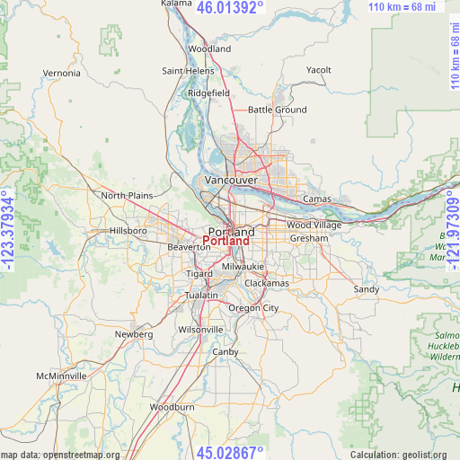
Portland GPS coordinates[2]
45° 31' 24.42" North, 122° 40' 34.356" West
| Map corner | latitude | longitude |
|---|---|---|
| Upper-left | 46.01392°, | -123.37934° |
| Center: | 45.52345°, | -122.67621° |
| Lower-right: | 45.02867°, | -121.97309° |
| Map W x H: | 109.5×109.5 km | = 68×68mi |
| max Lat: | 71.29058° ⇑5.9% North |
| Portland: | 45.52345° |
| min Lat: | ⇓94.1% South 19.06759° |
| min Long | Portland | max Long |
| -171.73463° | -122.67621° | -66.98998° |
| W 2.8%⇐ | ⇒97.2% E |
Elevation
Elevation of Portland is 15 m = 49 ft, and this is 279.8 m = 918 ft below average elevation for this country.
| Max E: |
3189 m = 10463 ft | 90.5% |
| Avg. | 294.8 m = 967 ft | |
| Portland | 15 m = 49 ft | |
Min E: |
-60 m = -197 ft | 9.5% |
See also: Portland elevation on elevation.city.
Geographical zone
Portland is located in North temperate zone (between Tropic of Cancer and the Arctic Circle). Distance of this North polar circle is 2339.4 km =1453.6 mi to North.| Distance of | km | miles | from Portland |
|---|---|---|---|
| North Pole | 4945.3 | 3072.9 | to North |
| Arctic Circle | 2339.4 | 1453.6 | to North |
| Tropic Cancer | 2455.8 | 1526 | to South |
| Equator | 5061.7 | 3145.2 | to South |


Nearby cities:
15 places around Portland: (largest is in red/bold)
• Beaverton
10.7 km =6.6 mi,  247°
247°
• Bridgeton
8.7 km =5.4 mi,  3°
3°
• Cedar Hills
9.7 km =6 mi,  257°
257°
• Cedar Mill
10.5 km =6.5 mi,  270°
270°
• Garden Home-Whitford
9.2 km =5.7 mi,  224°
224°
• Kenton
6.5 km =4 mi,  356°
356°
• Lents
9.8 km =6.1 mi,  119°
119°
• Maywood Park
9.6 km =6 mi,  70°
70°
• Metzger
10.7 km =6.6 mi, 217°
• Milwaukie
9.1 km =5.7 mi,  161°
161°
• North Portland
9.9 km =6.2 mi,  347°
347°
• Raleigh Hills
8.2 km =5.1 mi,  234°
234°
• West Haven
7.3 km =4.5 mi, 264°
• West Haven-Sylvan
7.2 km =4.5 mi, 263°
• West Slope
7.4 km =4.6 mi, 248°
Sources, notices
• [Note1] Compared only with cities in United States existing in our database
• [Src1] Map data: © OpenStreetMap contributors (CC-BY-SA)
• [Src2] Other city data from geonames.org with taken over terms of usage.
• [Src3] Geographical zone / Annual Mean Temperature by Robert A. Rohde @ Wikipedia
