Garden Home-Whitford geodata
Garden Home-Whitford (Oregon) is a populated place; located in United States in America/Los_Angeles (GMT-7) time zone. With population of 6,674 people, there are 5999 cities with bigger population in this country. Compared to other cities in United States, 93.9% of cities are located further ↓South; 97.3% of cities are located further →East and 73.3% of cities have higher elevation than Garden Home-Whitford. Note1


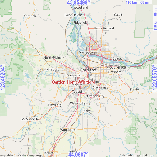
Garden Home-Whitford GPS coordinates[2]
45° 27' 50.4" North, 122° 45' 32.076" West
| Map corner | latitude | longitude |
|---|---|---|
| Upper-left | 45.95499°, | -123.46204° |
| Center: | 45.464°, | -122.75891° |
| Lower-right: | 44.9687°, | -122.05579° |
| Map W x H: | 109.7×109.7 km | = 68.2×68.2mi |
| max Lat: | 71.29058° ⇑6.1% North |
| Garden Home-Whitford: | 45.464° |
| min Lat: | ⇓93.9% South 19.06759° |
| min Long | Garden Home-Whi | max Long |
| -171.73463° | -122.75891° | -66.98998° |
| W 2.7%⇐ | ⇒97.3% E |
Elevation
Elevation of Garden Home-Whitford is 81 m = 266 ft, and this is 213.8 m = 701 ft below average elevation for this country.
| Max E: |
3189 m = 10463 ft | 73.3% |
| Avg. | 294.8 m = 967 ft | |
| Garden Home-Whitford | 81 m = 266 ft | |
Min E: |
-60 m = -197 ft | 26.7% |
See also: United States elevation on elevation.city.
Geographical zone
Garden Home-Whitford is located in North temperate zone (between Tropic of Cancer and the Arctic Circle). Distance of this North polar circle is 2346.1 km =1457.8 mi to North.| Distance of | km | miles | from Garden Home-Whitford |
|---|---|---|---|
| North Pole | 4951.9 | 3077 | to North |
| Arctic Circle | 2346.1 | 1457.8 | to North |
| Tropic Cancer | 2449.2 | 1521.9 | to South |
| Equator | 5055.1 | 3141.1 | to South |


Nearby cities:
15 places around Garden Home-Whitford: (largest is in red/bold)
• Aloha
9.1 km =5.7 mi,  291°
291°
• Beaverton
4.3 km =2.7 mi,  306°
306°
• Cedar Hills
5.5 km =3.4 mi,  325°
325°
• Cedar Mill
7.9 km =4.9 mi, 329°
• Durham
6.9 km =4.3 mi,  176°
176°
• King City
7.7 km =4.8 mi,  207°
207°
• Lake Oswego
8.4 km =5.2 mi,  124°
124°
• Metzger
1.9 km =1.2 mi, 180°
• Portland
9.2 km =5.7 mi,  44°
44°
• Raleigh Hills
1.9 km =1.2 mi,  352°
352°
• Tigard
3.8 km =2.4 mi,  195°
195°
• Tualatin
8.9 km =5.5 mi, 182°
• West Haven
6 km =3.7 mi, 352°
• West Haven-Sylvan
5.8 km =3.6 mi, 352°
• West Slope
3.9 km =2.4 mi, 353°
Sources, notices
• [Note1] Compared only with cities in United States existing in our database
• [Src1] Map data: © OpenStreetMap contributors (CC-BY-SA)
• [Src2] Other city data from geonames.org with taken over terms of usage.
• [Src3] Geographical zone / Annual Mean Temperature by Robert A. Rohde @ Wikipedia
