Willamina geodata
Willamina (Oregon) is a populated place; located in United States in America/Los_Angeles (GMT-7) time zone. With population of 2,106 people, there are 11600 cities with bigger population in this country. Compared to other cities in United States, 92.9% of cities are located further ↓South; 98.3% of cities are located further →East and 75.3% of cities have higher elevation than Willamina. Note1


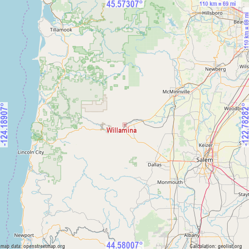
Willamina GPS coordinates[2]
45° 4' 43.428" North, 123° 29' 9.384" West
| Map corner | latitude | longitude |
|---|---|---|
| Upper-left | 45.57307°, | -124.18907° |
| Center: | 45.07873°, | -123.48594° |
| Lower-right: | 44.58007°, | -122.78282° |
| Map W x H: | 110.4×110.4 km | = 68.6×68.6mi |
| max Lat: | 71.29058° ⇑7.1% North |
| Willamina: | 45.07873° |
| min Lat: | ⇓92.9% South 19.06759° |
| min Long | Willamina | max Long |
| -171.73463° | -123.48594° | -66.98998° |
| W 1.7%⇐ | ⇒98.3% E |
Elevation
Elevation of Willamina is 70 m = 230 ft, and this is 224.8 m = 738 ft below average elevation for this country.
| Max E: |
3189 m = 10463 ft | 75.3% |
| Avg. | 294.8 m = 967 ft | |
| Willamina | 70 m = 230 ft | |
Min E: |
-60 m = -197 ft | 24.7% |
See also: United States elevation on elevation.city.
Geographical zone
Willamina is located in North temperate zone (between Tropic of Cancer and the Arctic Circle). Distance of this North polar circle is 2388.9 km =1484.4 mi to North.| Distance of | km | miles | from Willamina |
|---|---|---|---|
| North Pole | 4994.8 | 3103.6 | to North |
| Arctic Circle | 2388.9 | 1484.4 | to North |
| Tropic Cancer | 2406.4 | 1495.3 | to South |
| Equator | 5012.3 | 3114.5 | to South |


Nearby cities:
15 places around Willamina: (largest is in red/bold)
• Amity
22.3 km =13.9 mi,  79°
79°
• Carlton
34.1 km =21.2 mi,  45°
45°
• Dallas
22.2 km =13.8 mi,  143°
143°
• Dayton
35.8 km =22.2 mi,  63°
63°
• Falls City
24 km =14.9 mi,  170°
170°
• Grand Ronde
9.9 km =6.2 mi,  257°
257°
• Independence
34.6 km =21.5 mi, 137°
• Keizer
37.4 km =23.2 mi,  105°
105°
• Lafayette
34.4 km =21.4 mi, 57°
• McMinnville
26.8 km =16.7 mi, 57°
• Monmouth
32.4 km =20.1 mi, 142°
• Rose Lodge
31.9 km =19.8 mi, 256°
• Salem
38.5 km =23.9 mi, 113°
• Sheridan
7.5 km =4.7 mi,  72°
72°
• Yamhill
37.4 km =23.2 mi,  38°
38°
Sources, notices
• [Note1] Compared only with cities in United States existing in our database
• [Src1] Map data: © OpenStreetMap contributors (CC-BY-SA)
• [Src2] Other city data from geonames.org with taken over terms of usage.
• [Src3] Geographical zone / Annual Mean Temperature by Robert A. Rohde @ Wikipedia
