Union geodata
Union (Oregon) is a populated place; located in United States in America/Los_Angeles (GMT-7) time zone. With population of 2,120 people, there are 11553 cities with bigger population in this country. Compared to other cities in United States, 93.2% of cities are located further ↓South; 90.7% of cities are located further →East and 92.4% of cities have lower elevation than Union. Note1


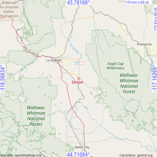
Union GPS coordinates[2]
45° 12' 30.492" North, 117° 51' 54.756" West
| Map corner | latitude | longitude |
|---|---|---|
| Upper-left | 45.70169°, | -118.56834° |
| Center: | 45.20847°, | -117.86521° |
| Lower-right: | 44.71094°, | -117.16209° |
| Map W x H: | 110.2×110.2 km | = 68.5×68.5mi |
| max Lat: | 71.29058° ⇑6.8% North |
| Union: | 45.20847° |
| min Lat: | ⇓93.2% South 19.06759° |
| min Long | Union | max Long |
| -171.73463° | -117.86521° | -66.98998° |
| W 9.3%⇐ | ⇒90.7% E |
Elevation
Elevation of Union is 849 m = 2785 ft, and this is 554.2 m = 1818 ft above average elevation for this country.
| Max E: |
3189 m = 10463 ft | 7.6% |
| Union | 849 m 2785 ft | |
| Avg. | 294.8 m = 967 ft | |
Min E: |
-60 m = -197 ft | 92.4% |
See also: United States elevation on elevation.city.
Geographical zone
Union is located in North temperate zone (between Tropic of Cancer and the Arctic Circle). Distance of this North polar circle is 2374.5 km =1475.4 mi to North.| Distance of | km | miles | from Union |
|---|---|---|---|
| North Pole | 4980.4 | 3094.7 | to North |
| Arctic Circle | 2374.5 | 1475.4 | to North |
| Tropic Cancer | 2420.8 | 1504.2 | to South |
| Equator | 5026.7 | 3123.4 | to South |


Nearby cities:
15 places around Union: (largest is in red/bold)
• Athena
82.9 km =51.5 mi,  324°
324°
• Baker City
48.3 km =30 mi,  177°
177°
• Cove
10.8 km =6.7 mi,  24°
24°
• Elgin
39.8 km =24.7 mi,  354°
354°
• Enterprise
51.9 km =32.2 mi,  62°
62°
• Island City
20.4 km =12.7 mi, 316°
• Joseph
52.3 km =32.5 mi,  71°
71°
• La Grande
21.7 km =13.5 mi,  306°
306°
• Milton-Freewater
90.2 km =56 mi,  333°
333°
• Mission
81.9 km =50.9 mi, 308°
• Pendleton
88.6 km =55.1 mi, 305°
• Pilot Rock
81.3 km =50.5 mi,  292°
292°
• Walla Walla East
99.8 km =62 mi,  340°
340°
• Wallowa
48.1 km =29.9 mi,  33°
33°
• Weston
80.2 km =49.8 mi, 327°
Sources, notices
• [Note1] Compared only with cities in United States existing in our database
• [Src1] Map data: © OpenStreetMap contributors (CC-BY-SA)
• [Src2] Other city data from geonames.org with taken over terms of usage.
• [Src3] Geographical zone / Annual Mean Temperature by Robert A. Rohde @ Wikipedia
