Milton-Freewater geodata
Milton-Freewater (Oregon) is a populated place; located in United States in America/Los_Angeles (GMT-7) time zone. With population of 7,035 people, there are 5793 cities with bigger population in this country. Compared to other cities in United States, 95% of cities are located further ↓South; 91.4% of cities are located further →East and 75.7% of cities have lower elevation than Milton-Freewater. Note1


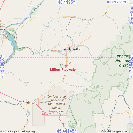
Milton-Freewater GPS coordinates[2]
45° 55' 57.468" North, 118° 23' 15.864" West
| Map corner | latitude | longitude |
|---|---|---|
| Upper-left | 46.4195°, | -119.09087° |
| Center: | 45.93263°, | -118.38774° |
| Lower-right: | 45.44145°, | -117.68462° |
| Map W x H: | 108.7×108.7 km | = 67.5×67.5mi |
| max Lat: | 71.29058° ⇑5% North |
| Milton-Freewater: | 45.93263° |
| min Lat: | ⇓95% South 19.06759° |
| min Long | Milton-Freewate | max Long |
| -171.73463° | -118.38774° | -66.98998° |
| W 8.6%⇐ | ⇒91.4% E |
Elevation
Elevation of Milton-Freewater is 318 m = 1043 ft, and this is 23.2 m = 76 ft above average elevation for this country.
| Max E: |
3189 m = 10463 ft | 24.3% |
| Milton-Freewater | 318 m 1043 ft | |
| Avg. | 294.8 m = 967 ft | |
Min E: |
-60 m = -197 ft | 75.7% |
See also: United States elevation on elevation.city.
Geographical zone
Milton-Freewater is located in North temperate zone (between Tropic of Cancer and the Arctic Circle). Distance of this North polar circle is 2293.9 km =1425.4 mi to North.| Distance of | km | miles | from Milton-Freewater |
|---|---|---|---|
| North Pole | 4899.8 | 3044.6 | to North |
| Arctic Circle | 2293.9 | 1425.4 | to North |
| Tropic Cancer | 2501.3 | 1554.2 | to South |
| Equator | 5107.2 | 3173.5 | to South |


Nearby cities:
15 places around Milton-Freewater: (largest is in red/bold)
• Athena
15.6 km =9.7 mi,  210°
210°
• Burbank
56.7 km =35.2 mi,  301°
301°
• College Place
13 km =8.1 mi,  359°
359°
• Dayton
54 km =33.6 mi,  36°
36°
• Elgin
54.8 km =34.1 mi,  138°
138°
• Finley
55.6 km =34.5 mi, 296°
• Garrett
13.3 km =8.3 mi, 355°
• Highland
60.3 km =37.5 mi,  291°
291°
• Mission
37.1 km =23.1 mi,  218°
218°
• Pendleton
42.5 km =26.4 mi,  227°
227°
• Pilot Rock
60.6 km =37.7 mi, 214°
• Waitsburg
41.7 km =25.9 mi,  25°
25°
• Walla Walla
15.1 km =9.4 mi,  13°
13°
• Walla Walla East
14.7 km =9.1 mi, 26°
• Weston
13.5 km =8.4 mi,  192°
192°
Sources, notices
• [Note1] Compared only with cities in United States existing in our database
• [Src1] Map data: © OpenStreetMap contributors (CC-BY-SA)
• [Src2] Other city data from geonames.org with taken over terms of usage.
• [Src3] Geographical zone / Annual Mean Temperature by Robert A. Rohde @ Wikipedia
