Weston geodata
Weston (Oregon) is a populated place; located in United States in America/Los_Angeles (GMT-7) time zone. With population of 647 people, there are 19202 cities with bigger population in this country. Compared to other cities in United States, 94.8% of cities are located further ↓South; 91.5% of cities are located further →East and 89% of cities have lower elevation than Weston. Note1


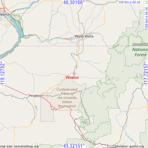
Weston GPS coordinates[2]
45° 48' 49.464" North, 118° 25' 28.884" West
| Map corner | latitude | longitude |
|---|---|---|
| Upper-left | 46.30166°, | -119.12782° |
| Center: | 45.81374°, | -118.42469° |
| Lower-right: | 45.32151°, | -117.72157° |
| Map W x H: | 109×109 km | = 67.7×67.7mi |
| max Lat: | 71.29058° ⇑5.2% North |
| Weston: | 45.81374° |
| min Lat: | ⇓94.8% South 19.06759° |
| min Long | Weston | max Long |
| -171.73463° | -118.42469° | -66.98998° |
| W 8.5%⇐ | ⇒91.5% E |
Elevation
Elevation of Weston is 563 m = 1847 ft, and this is 268.2 m = 880 ft above average elevation for this country.
| Max E: |
3189 m = 10463 ft | 11% |
| Weston | 563 m 1847 ft | |
| Avg. | 294.8 m = 967 ft | |
Min E: |
-60 m = -197 ft | 89% |
See also: United States elevation on elevation.city.
Geographical zone
Weston is located in North temperate zone (between Tropic of Cancer and the Arctic Circle). Distance of this North polar circle is 2307.2 km =1433.6 mi to North.| Distance of | km | miles | from Weston |
|---|---|---|---|
| North Pole | 4913.1 | 3052.9 | to North |
| Arctic Circle | 2307.2 | 1433.6 | to North |
| Tropic Cancer | 2488.1 | 1546 | to South |
| Equator | 5094 | 3165.3 | to South |


Nearby cities:
15 places around Weston: (largest is in red/bold)
• Athena
5.1 km =3.2 mi,  267°
267°
• College Place
26.3 km =16.3 mi,  6°
6°
• Echo
60.3 km =37.5 mi,  262°
262°
• Elgin
48.1 km =29.9 mi,  125°
125°
• Finley
60.4 km =37.5 mi,  308°
308°
• Garrett
26.6 km =16.5 mi,  3°
3°
• Island City
60.3 km =37.5 mi,  150°
150°
• La Grande
60.4 km =37.5 mi, 154°
• Milton-Freewater
13.5 km =8.4 mi, 12°
• Mission
25.6 km =15.9 mi,  231°
231°
• Pendleton
32.3 km =20.1 mi,  240°
240°
• Pilot Rock
48.4 km =30.1 mi,  220°
220°
• Waitsburg
54.9 km =34.1 mi,  22°
22°
• Walla Walla
28.6 km =17.8 mi, 12°
• Walla Walla East
28.1 km =17.5 mi, 19°
Sources, notices
• [Note1] Compared only with cities in United States existing in our database
• [Src1] Map data: © OpenStreetMap contributors (CC-BY-SA)
• [Src2] Other city data from geonames.org with taken over terms of usage.
• [Src3] Geographical zone / Annual Mean Temperature by Robert A. Rohde @ Wikipedia
