Benson geodata
Benson (Utah) is a populated place; located in United States in America/Denver (GMT-6) time zone. With population of 1,485 people, there are 13721 cities with bigger population in this country. Compared to other cities in United States, 73.8% of cities are located further ↓South; 87.3% of cities are located further →East and 95.6% of cities have lower elevation than Benson. Note1


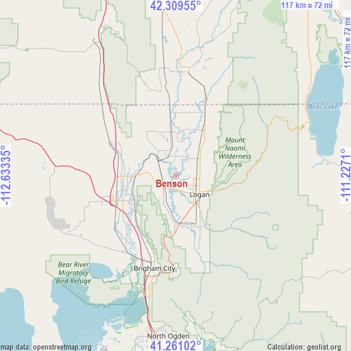
Benson GPS coordinates[2]
41° 47' 14.748" North, 111° 55' 48.792" West
| Map corner | latitude | longitude |
|---|---|---|
| Upper-left | 42.30955°, | -112.63335° |
| Center: | 41.78743°, | -111.93022° |
| Lower-right: | 41.26102°, | -111.2271° |
| Map W x H: | 116.6×116.6 km | = 72.5×72.5mi |
| max Lat: | 71.29058° ⇑26.2% North |
| Benson: | 41.78743° |
| min Lat: | ⇓73.8% South 19.06759° |
| min Long | Benson | max Long |
| -171.73463° | -111.93022° | -66.98998° |
| W 12.7%⇐ | ⇒87.3% E |
Elevation
Elevation of Benson is 1350 m = 4429 ft, and this is 1055.2 m = 3462 ft above average elevation for this country.
| Max E: |
3189 m = 10463 ft | 4.4% |
| Benson | 1350 m 4429 ft | |
| Avg. | 294.8 m = 967 ft | |
Min E: |
-60 m = -197 ft | 95.6% |
See also: United States elevation on elevation.city.
Geographical zone
Benson is located in North temperate zone (between Tropic of Cancer and the Arctic Circle). Distance of this Northern Tropic circle is 2040.4 km =1267.8 mi to South.| Distance of | km | miles | from Benson |
|---|---|---|---|
| North Pole | 5360.7 | 3331 | to North |
| Arctic Circle | 2754.8 | 1711.8 | to North |
| Tropic Cancer | 2040.4 | 1267.8 | to South |
| Equator | 4646.3 | 2887.1 | to South |


Nearby cities:
15 places around Benson: (largest is in red/bold)
• Amalga
8.7 km =5.4 mi,  19°
19°
• Clarkston
17.8 km =11.1 mi,  326°
326°
• Hyde Park
9.3 km =5.8 mi,  82°
82°
• Logan
9.8 km =6.1 mi,  126°
126°
• Mendon
9.5 km =5.9 mi,  204°
204°
• Millville
14.8 km =9.2 mi,  142°
142°
• Newton
9.8 km =6.1 mi, 329°
• Nibley
14.9 km =9.3 mi,  147°
147°
• North Logan
10.6 km =6.6 mi,  100°
100°
• Providence
13 km =8.1 mi, 133°
• Richmond
17.9 km =11.1 mi,  32°
32°
• River Heights
11.6 km =7.2 mi, 129°
• Smithfield
9.9 km =6.2 mi,  55°
55°
• Trenton
14.5 km =9 mi,  355°
355°
• Wellsville
16.6 km =10.3 mi,  181°
181°
Sources, notices
• [Note1] Compared only with cities in United States existing in our database
• [Src1] Map data: © OpenStreetMap contributors (CC-BY-SA)
• [Src2] Other city data from geonames.org with taken over terms of usage.
• [Src3] Geographical zone / Annual Mean Temperature by Robert A. Rohde @ Wikipedia
