Logan geodata
Logan (Utah) is a seat of a second-order administrative division; located in United States in America/Denver (GMT-6) time zone. With population of 50,371 people, there are 942 cities with bigger population in this country. Compared to other cities in United States, 73.3% of cities are located further ↓South; 87.1% of cities are located further →East and 95.8% of cities have lower elevation than Logan. Note1


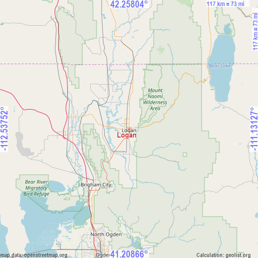
Logan GPS coordinates[2]
41° 44' 7.764" North, 111° 50' 3.804" West
| Map corner | latitude | longitude |
|---|---|---|
| Upper-left | 42.25804°, | -112.53752° |
| Center: | 41.73549°, | -111.83439° |
| Lower-right: | 41.20866°, | -111.13127° |
| Map W x H: | 116.7×116.7 km | = 72.5×72.5mi |
| max Lat: | 71.29058° ⇑26.7% North |
| Logan: | 41.73549° |
| min Lat: | ⇓73.3% South 19.06759° |
| min Long | Logan | max Long |
| -171.73463° | -111.83439° | -66.98998° |
| W 12.9%⇐ | ⇒87.1% E |
Elevation
Elevation of Logan is 1381 m = 4531 ft, and this is 1086.2 m = 3564 ft above average elevation for this country.
| Max E: |
3189 m = 10463 ft | 4.2% |
| Logan | 1381 m 4531 ft | |
| Avg. | 294.8 m = 967 ft | |
Min E: |
-60 m = -197 ft | 95.8% |
See also: Logan elevation on elevation.city.
Geographical zone
Logan is located in North temperate zone (between Tropic of Cancer and the Arctic Circle). Distance of this Northern Tropic circle is 2034.6 km =1264.2 mi to South.| Distance of | km | miles | from Logan |
|---|---|---|---|
| North Pole | 5366.5 | 3334.6 | to North |
| Arctic Circle | 2760.6 | 1715.4 | to North |
| Tropic Cancer | 2034.6 | 1264.2 | to South |
| Equator | 4640.6 | 2883.5 | to South |


Nearby cities:
15 places around Logan: (largest is in red/bold)
• Amalga
14.9 km =9.3 mi,  339°
339°
• Benson
9.8 km =6.1 mi,  306°
306°
• Hyde Park
7.2 km =4.5 mi,  10°
10°
• Hyrum
11.4 km =7.1 mi,  187°
187°
• Mendon
12.2 km =7.6 mi,  256°
256°
• Millville
6.1 km =3.8 mi,  171°
171°
• Newton
19.2 km =11.9 mi,  317°
317°
• Nibley
6.8 km =4.2 mi,  179°
179°
• North Logan
4.5 km =2.8 mi,  33°
33°
• Paradise
18.5 km =11.5 mi, 180°
• Providence
3.5 km =2.2 mi,  156°
156°
• Richmond
20.9 km =13 mi,  4°
4°
• River Heights
1.9 km =1.2 mi,  144°
144°
• Smithfield
11.4 km =7.1 mi, 0°
• Wellsville
13.6 km =8.5 mi,  217°
217°
Sources, notices
• [Note1] Compared only with cities in United States existing in our database
• [Src1] Map data: © OpenStreetMap contributors (CC-BY-SA)
• [Src2] Other city data from geonames.org with taken over terms of usage.
• [Src3] Geographical zone / Annual Mean Temperature by Robert A. Rohde @ Wikipedia
