Orem geodata
Orem (Utah) is a populated place; located in United States in America/Denver (GMT-6) time zone. With population of 94,457 people, there are 382 cities with bigger population in this country. Compared to other cities in United States, 56.6% of cities are located further ↓South; 86.8% of cities are located further →East and 96.4% of cities have lower elevation than Orem. Note1


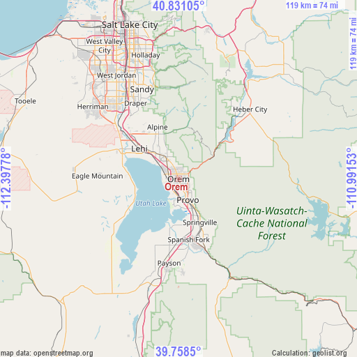
Orem GPS coordinates[2]
40° 17' 48.84" North, 111° 41' 40.74" West
| Map corner | latitude | longitude |
|---|---|---|
| Upper-left | 40.83105°, | -112.39778° |
| Center: | 40.2969°, | -111.69465° |
| Lower-right: | 39.7585°, | -110.99153° |
| Map W x H: | 119.3×119.3 km | = 74.1×74.1mi |
| max Lat: | 71.29058° ⇑43.4% North |
| Orem: | 40.2969° |
| min Lat: | ⇓56.6% South 19.06759° |
| min Long | Orem | max Long |
| -171.73463° | -111.69465° | -66.98998° |
| W 13.2%⇐ | ⇒86.8% E |
Elevation
Elevation of Orem is 1458 m = 4783 ft, and this is 1163.2 m = 3816 ft above average elevation for this country.
| Max E: |
3189 m = 10463 ft | 3.6% |
| Orem | 1458 m 4783 ft | |
| Avg. | 294.8 m = 967 ft | |
Min E: |
-60 m = -197 ft | 96.4% |
See also: Orem elevation on elevation.city.
Geographical zone
Orem is located in North temperate zone (between Tropic of Cancer and the Arctic Circle). Distance of this Northern Tropic circle is 1874.7 km =1164.9 mi to South.| Distance of | km | miles | from Orem |
|---|---|---|---|
| North Pole | 5526.5 | 3434 | to North |
| Arctic Circle | 2920.6 | 1814.8 | to North |
| Tropic Cancer | 1874.7 | 1164.9 | to South |
| Equator | 4480.6 | 2784.1 | to South |


Nearby cities:
15 places around Orem: (largest is in red/bold)
• Alpine
18.8 km =11.7 mi,  337°
337°
• American Fork
12.4 km =7.7 mi,  316°
316°
• Benjamin
22.3 km =13.9 mi,  188°
188°
• Cedar Hills
14.1 km =8.8 mi, 337°
• Highland
16.6 km =10.3 mi,  329°
329°
• Lake Shore
19.7 km =12.2 mi, 188°
• Lehi
16.9 km =10.5 mi,  308°
308°
• Lindon
5.6 km =3.5 mi, 336°
• Mapleton
21 km =13 mi,  151°
151°
• Pleasant Grove
8.3 km =5.2 mi, 333°
• Provo
7.7 km =4.8 mi,  156°
156°
• Saratoga Springs
18.7 km =11.6 mi,  288°
288°
• Spanish Fork
20.5 km =12.7 mi,  170°
170°
• Springville
16.3 km =10.1 mi, 154°
• Vineyard
4.4 km =2.7 mi,  270°
270°
Sources, notices
• [Note1] Compared only with cities in United States existing in our database
• [Src1] Map data: © OpenStreetMap contributors (CC-BY-SA)
• [Src2] Other city data from geonames.org with taken over terms of usage.
• [Src3] Geographical zone / Annual Mean Temperature by Robert A. Rohde @ Wikipedia
