Lehi geodata
Lehi (Utah) is a populated place; located in United States in America/Denver (GMT-6) time zone. With population of 58,486 people, there are 777 cities with bigger population in this country. Compared to other cities in United States, 57.7% of cities are located further ↓South; 87.1% of cities are located further →East and 96% of cities have lower elevation than Lehi. Note1


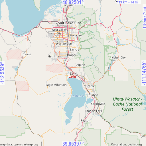
Lehi GPS coordinates[2]
40° 23' 29.832" North, 111° 51' 2.772" West
| Map corner | latitude | longitude |
|---|---|---|
| Upper-left | 40.92501°, | -112.5539° |
| Center: | 40.39162°, | -111.85077° |
| Lower-right: | 39.85397°, | -111.14765° |
| Map W x H: | 119.1×119.1 km | = 74×74mi |
| max Lat: | 71.29058° ⇑42.3% North |
| Lehi: | 40.39162° |
| min Lat: | ⇓57.7% South 19.06759° |
| min Long | Lehi | max Long |
| -171.73463° | -111.85077° | -66.98998° |
| W 12.9%⇐ | ⇒87.1% E |
Elevation
Elevation of Lehi is 1397 m = 4583 ft, and this is 1102.2 m = 3616 ft above average elevation for this country.
| Max E: |
3189 m = 10463 ft | 4% |
| Lehi | 1397 m 4583 ft | |
| Avg. | 294.8 m = 967 ft | |
Min E: |
-60 m = -197 ft | 96% |
See also: Lehi elevation on elevation.city.
Geographical zone
Lehi is located in North temperate zone (between Tropic of Cancer and the Arctic Circle). Distance of this Northern Tropic circle is 1885.2 km =1171.4 mi to South.| Distance of | km | miles | from Lehi |
|---|---|---|---|
| North Pole | 5515.9 | 3427.4 | to North |
| Arctic Circle | 2910 | 1808.2 | to North |
| Tropic Cancer | 1885.2 | 1171.4 | to South |
| Equator | 4491.1 | 2790.6 | to South |


Nearby cities:
15 places around Lehi: (largest is in red/bold)
• Alpine
9.2 km =5.7 mi,  41°
41°
• American Fork
4.9 km =3 mi,  109°
109°
• Bluffdale
13.2 km =8.2 mi,  325°
325°
• Cedar Hills
8.2 km =5.1 mi,  72°
72°
• Draper
14.8 km =9.2 mi,  355°
355°
• Eagle Mountain
15.8 km =9.8 mi,  236°
236°
• Highland
6.1 km =3.8 mi,  51°
51°
• Lindon
12.3 km =7.6 mi,  116°
116°
• Orem
16.9 km =10.5 mi,  128°
128°
• Pleasant Grove
10 km =6.2 mi, 107°
• Riverton
16.3 km =10.1 mi, 332°
• Saratoga Springs
6.6 km =4.1 mi,  224°
224°
• South Jordan
20.1 km =12.5 mi,  340°
340°
• Vineyard
13.7 km =8.5 mi,  140°
140°
• White City
19.4 km =12.1 mi, 356°
Sources, notices
• [Note1] Compared only with cities in United States existing in our database
• [Src1] Map data: © OpenStreetMap contributors (CC-BY-SA)
• [Src2] Other city data from geonames.org with taken over terms of usage.
• [Src3] Geographical zone / Annual Mean Temperature by Robert A. Rohde @ Wikipedia
