Pleasant Grove geodata
Pleasant Grove (Utah) is a populated place; located in United States in America/Denver (GMT-6) time zone. With population of 38,052 people, there are 1275 cities with bigger population in this country. Compared to other cities in United States, 57.4% of cities are located further ↓South; 86.9% of cities are located further →East and 96.1% of cities have lower elevation than Pleasant Grove. Note1


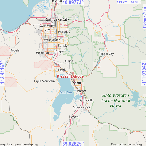
Pleasant Grove GPS coordinates[2]
40° 21' 50.832" North, 111° 44' 18.744" West
| Map corner | latitude | longitude |
|---|---|---|
| Upper-left | 40.89773°, | -112.44167° |
| Center: | 40.36412°, | -111.73854° |
| Lower-right: | 39.82625°, | -111.03542° |
| Map W x H: | 119.1×119.1 km | = 74×74mi |
| max Lat: | 71.29058° ⇑42.6% North |
| Pleasant Grove: | 40.36412° |
| min Lat: | ⇓57.4% South 19.06759° |
| min Long | Pleasant Grove | max Long |
| -171.73463° | -111.73854° | -66.98998° |
| W 13.1%⇐ | ⇒86.9% E |
Elevation
Elevation of Pleasant Grove is 1416 m = 4646 ft, and this is 1121.2 m = 3678 ft above average elevation for this country.
| Max E: |
3189 m = 10463 ft | 3.9% |
| Pleasant Grove | 1416 m 4646 ft | |
| Avg. | 294.8 m = 967 ft | |
Min E: |
-60 m = -197 ft | 96.1% |
See also: United States elevation on elevation.city.
Geographical zone
Pleasant Grove is located in North temperate zone (between Tropic of Cancer and the Arctic Circle). Distance of this Northern Tropic circle is 1882.2 km =1169.5 mi to South.| Distance of | km | miles | from Pleasant Grove |
|---|---|---|---|
| North Pole | 5519 | 3429.3 | to North |
| Arctic Circle | 2913.1 | 1810.1 | to North |
| Tropic Cancer | 1882.2 | 1169.5 | to South |
| Equator | 4488.1 | 2788.8 | to South |


Nearby cities:
15 places around Pleasant Grove: (largest is in red/bold)
• Alpine
10.5 km =6.5 mi,  341°
341°
• American Fork
5.1 km =3.2 mi,  286°
286°
• Bluffdale
22 km =13.7 mi,  309°
309°
• Cedar Hills
5.8 km =3.6 mi, 343°
• Draper
20.8 km =12.9 mi,  329°
329°
• Eagle Mountain
23.4 km =14.5 mi,  256°
256°
• Granite
23.9 km =14.9 mi,  346°
346°
• Highland
8.3 km =5.2 mi, 325°
• Lehi
10 km =6.2 mi, 287°
• Lindon
2.8 km =1.7 mi,  146°
146°
• Orem
8.3 km =5.2 mi, 153°
• Provo
16 km =9.9 mi, 154°
• Riverton
24.4 km =15.2 mi,  315°
315°
• Saratoga Springs
14.2 km =8.8 mi, 263°
• Vineyard
7.5 km =4.7 mi,  185°
185°
Sources, notices
• [Note1] Compared only with cities in United States existing in our database
• [Src1] Map data: © OpenStreetMap contributors (CC-BY-SA)
• [Src2] Other city data from geonames.org with taken over terms of usage.
• [Src3] Geographical zone / Annual Mean Temperature by Robert A. Rohde @ Wikipedia
